
Soil/Landform Unit 167
Landform Unit Description
Page top
 Plains north of Peterborough in the extreme south-west of the Corangamite catchment |
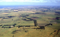
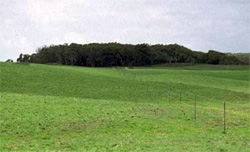
0.11% of CMA region East of Warrnambool near Mepunga are extensive sand sheets with underlying Neogene sediments including Port Campbell Limestone and Gellibrand Marl. This area is characterised by an undulating terrain that has numerous blow-outs and depressions that have developed in the limestone. As part of the Western Plains, this unit is situated on the south-western margin of the Curdies River and continues well into the Glenelg-Hopkins catchment. Soils typically comprise sandy yellow and brown texture contrast soils (Podosols and Kurosols) associated with the sands, and black texture contrast soils (Kurosols) of the limestone. Native vegetation on these plains is mainly composed of Coastal Headland Scrub, Herb-rich Foothill Forest and Damp Heathland/Damp Heathy Woodland Mosaic. Land use is mainly grazing for beef and dairy cattle with some cropping. Residential development along the south-west coast is also prominent. The main hazards to land use are loss of soil structure by compaction and leaching of nutrients. | 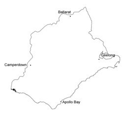 |
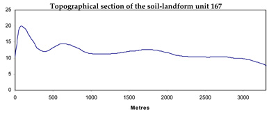
 Undulating plains and rises with sand overlying limeston | 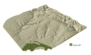 |
 |
Component | 1 | 2 |
Proportion of soil-landform unit | 97% | 3% |
| CLIMATE Rainfall (mm) | Annual: 850 | |
| Temperature (oC) | Minimum 10, Maximum 19 | |
| Precipitation less than potential evapotranspiration | October-March | |
| GEOLOGY Age and lithology | Neogene marine and calcarenite | |
| Geomorphology | ||
| LANDUSE | Uncleared areas: Hardwood forestry for sawlogs, posts and poles; water supply; nature conservation Cleared areas: Dairy farming; sheep and beef cattle grazing; residential development | |
| TOPOGRAPHY Landscape | Undulating plain | |
| Elevation range (m) | 2-53 | |
| Local relief (m) | 3-5 | |
| Drainage pattern | Dendritic | |
| Drainage density (km/km2) | 0.9 | |
| Landform | Undulating sand sheets | Depressions |
| Landform element | Plains | Blow out |
| Slope and range (%) | 3 (1-7) | 3 (1-8) |
| Slope shape | Straight | Concave |
| NATIVE VEGETATION Ecological Vegetation Class | Coastal Headland Scrub (606%); Herb-rich Foothill Forest (4.9%); Damp Healthland / Damp Heathy Woodland Mosaic (2.1%) | |
| SOIL Parent material | Aeolian sediments over limestone | Limestone |
| Description (Corangamite Soil Group) | Sandy mottled brown, grey or yellow texture contrast soils (8) | Black texture contrast soils (23) |
| Soil type sites | ||
| Surface texture | Loamy sand | Fine sandy loam |
| Permeability | High to very high | High to moderate |
| Depth (m) | >2 | <2 |
| LAND CHARACTERISTICS, POTENTIAL AND LIMITATIONS | Uniform sands or deep sand over clay, very low water holding capacity and nutrient holding capacity in sandy soil, high in clays. Poor structured ins andy soil component, susceptible to nutrient decline. Moderate site drainage. Some susceptibility to wind and sheet erosion. | Texture contrst, moderate water holding capacity and high nutrient holding capacity in upper soil, higher in subsoils. Strong structure. Moderate to low site drainage. Some susceptibility to wind and sheet erosion. |
© State of Victoria (Agriculture Victoria) 1996 - .

This work, Victorian Resources Online, is licensed under a Creative Commons Attribution 4.0 licence. You are free to re-use the work under that licence, on the condition that you credit the State of Victoria (Agriculture Victoria) as author, indicate if changes were made and comply with the other licence terms.
The licence does not apply to ‘branding’ or some ‘images or photographs’ that may be owned by third parties. We ask you to seek prior approval to use images using the VRO feedback form. Access to higher quality images can also be provided on request.
This page was last updated on .