CLRA8
|
| CLRA8 |  | |
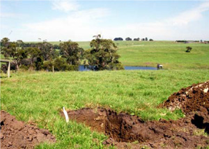
| Timboon (Timboon Curdie Vale Road), Heytesbury district, south-west Victoria | |||
| Dissected plateaux | |||
| Neogene Port Campbell Limestone: marine calcarenite, marl | |||
| Mid slope | |||
| 3% | |||
| North-west | |||
Horizon | Depth (cm) | |||
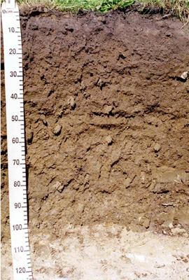
A11 | 0–10 | Very dark greyish brown (10YR3/2); very fine sandy clay loam; apedal single grain structure; rough ped fabric; firm consistence (moderately moist); non-calcareous, pH 8; gradual smooth boundary to: | ||
A12 | 10–17 | Dark greyish brown (10YR4/2) with brownish yellow (10YR6/6) mottles due to bioturbation; light medium clay; strong very fine subangular blocky structure; rough ped fabric; weak consistence (moist) and very firm consistence (dry); clear smooth boundary to: | ||
B21 | 17–55 | Yellowish brown (10YR5/4); medium clay; strong very fine polyhedral structure; rough and smooth ped fabric; weak consistence (moderately moist) and strong consistence (dry); non-calcareous, pH 7; clear smooth boundary to: | ||
B22 | 55–80 | Light olive brown (2.5Y5/4) with few brownish yellow (10YR6/6) mottles; medium heavy clay; strong fine and medium lenticular structure; smooth ped fabric; slickenside cutans; weak consistence (moist) and strong consistence (dry); non-calcareous, pH 5.5; clear smooth boundary to: | ||
B23 | 80–100 | Olive brown (2.5Y4/4) with many olive yellow (2.5Y6/6) mottles; medium clay; strong fine and medium lenticular structure; smooth ped fabric; mangans and slickenside cutans; weak consistence (moist) and strong consistence (dry); non-calcareous, pH 6; abrupt smooth boundary to: | ||
C | 100+ | Very highly calcareous, pH 8.5. | ||
| Management considerations | ||||
This soil is strongly texture contrast with a shallow surface soil. This is an acidic profile overlying calcareous parent material due mainly to the relatively high rainfall of the area. The subsoil has restricted drainage (colour, mottling) due to the high clay content of the subsoil and despite the limestone below. Nutrient levels are high particularly in the lower subsoil and the surface nutrient status has been altered by management to improve nutrient availability by increasing the pH. The shallow surface soil has limited depth for root penetration but high organic matter (10% OM) without which it would set hard (poor structure). The soils is quite stable, slightly less in the surface [Emerson 3(1)] compared with the subsoil [Emerson 5]. | ||||
Site CLRA8 | Sample depth | pH | EC | NaCl | Ex Ca | Ex Mg | Ex K | Ex Na | Ex Al | Ex Acidity | FC –10kPa | PWP –1500kPa | KS | FS | Z | C | |
Horizon | cm | H2O | CaCl2 | dS/m | % | cmolc/kg | cmolc/kg | cmolc/kg | cmolc/kg | mg/kg | cmolc/kg | % | % | % | % | % | % |
A11 | 0–10 | 6.8 | 6.3 | 0.26 | N/R | 17 | 4.5 | 2.6 | 0.76 | N/R | N/R | 50.5 | 26.3 | 5.9 | 33.9 | 25.5 | 22 |
B21 | 25–45 | 5.1 | 4.4 | 0.19 | N/R | 13 | 5.7 | 1.6 | 0.94 | N/R | N/R | 49.8 | 29.8 | 2.4 | 18.7 | 13 | 62 |
B22 | 60–75 | 5 | 4.5 | 0.36 | N/R | 21 | 7.6 | 1.1 | 1.6 | N/R | N/R | 58.9 | 37.1 | 2.6 | 13.5 | 12.5 | 66.5 |
B23 | 85–100 | 6.4 | 5.9 | 0.42 | N/R | 36 | 7.1 | 1.1 | 2 | N/R | N/R | N/R | N/R | N/R | N/R | N/R | N/R |
C | 100+ | 8.3 | 7.8 | 0.37 | N/R | N/R | N/R | N/R | N/R | N/R | N/R | N/R | N/R | N/R | N/R | N/R | N/R |


