
CLRA9
|
| CLRA9 | 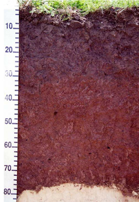 Haplic, Eutrophic, Red Kurosol | |
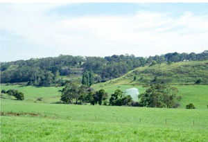
| Timboon (Timboon Curdie Vale Road), Heytesbury district, south-west Victoria | |||
| Dissected plateaux | |||
| Neogene Port Campbell Limestone: marine calcarenite, marl | |||
| Upper slope | |||
| 22% | |||
| West-south-west | |||
Horizon | Depth (cm) | Description | ||
A11 | 0–10 | Very dark greyish brown (10YR3/2); very fine sandy clay loam; strong fine to coarse subangular blocky structure; rough ped fabric; strong consistence (dry); pH 7; boundary to: | ||
A12 | 10–23 | Dark brown (10YR3/3); light clay; strong fine to coarse polyhedral structure; rough and smooth ped fabric; strong consistence (dry); pH 7; clear irregular boundary to: | ||
B21 | 23–75 | Dark reddish brown (5YR3/3); medium clay; strong very fine to fine polyhedral and lenticular structure; smooth ped fabric; strong consistence (dry); pH 5.5; sharp wavy boundary to: | ||
C | 75+ | Rock | ||
| Management considerations | ||||
This soil is texture contrast with a moderately deep surface soil and moderate soil depth (less than 1 metre), which has the potential for restricted drainage. This is an acidic profile overlying calcareous parent material due mainly to the relatively high rainfall of the area. The soil is well drained (red colour, no mottling) due to the soil structure despite the very high clay content and site drainage (22% slope) and the limestone below. Nutrient levels are high particularly in the lower subsoil and the surface nutrient status has been altered by management to improve nutrient availability by increasing the pH. The soil has reasonable depth for root penetration and high organic matter (8.4% OM) in the surface soil and the subsurface soil (5.9% OM). This soil is quite stable; very stable in the surface but slightly dispersive in the subsurface [Emerson 8 and 3(1)] and stable in the subsoil [Emerson 5]. | ||||
Site CLRA9 | Sample depth | pH | EC | NaCl | Ex Ca | Ex Mg | Ex K | Ex Na | Ex Al | Ex Acidity | FC –10kPa | PWP –1500kPa | KS | FS | Z | C | |
Horizon | cm | H2O | CaCl2 | dS/m | % | cmolc/kg | cmolc/kg | cmolc/kg | cmolc/kg | mg/kg | cmolc/kg | % | % | % | % | % | % |
A11 | 0–10 | 7 | 6.6 | 0.29 | N/R | 18 | 3.2 | 0.5 | 0.8 | N/R | N/R | 45.3 | 29.2 | 3.3 | 22.9 | 41 | 41 |
A12 | 10–20 | 6.6 | 6.1 | 0.15 | N/R | 22 | 4.7 | 0.63 | 0.92 | N/R | N/R | 41 | 24.3 | 1.4 | 25.5 | 20 | 44.5 |
B21 | 30–45 | 5.4 | 4.6 | 0.12 | N/R | 16 | 6 | 0.66 | 1.1 | N/R | N/R | 52.8 | 31.6 | 1 | 13.6 | 10.5 | 69.5 |
B21 | 50–65 | 5.1 | 4.4 | 0.2 | N/R | 19 | 5.4 | 0.73 | 1.3 | 580 | 23 | N/R | N/R | 0.5 | 8.4 | 3.5 | 82.5 |
B/C | 75–90 | 4.9 | 4.2 | 0.09 | N/R | N/R | N/R | N/R | N/R | N/R | N/R | N/R | N/R | N/R | N/R | N/R | N/R |
C | 100+ | 8.8 | 8.1 | 0.11 | N/R | N/R | N/R | N/R | N/R | N/R | N/R | N/R | N/R | N/R | N/R | N/R | N/R |
© State of Victoria (Agriculture Victoria) 1996 - .

This work, Victorian Resources Online, is licensed under a Creative Commons Attribution 4.0 licence. You are free to re-use the work under that licence, on the condition that you credit the State of Victoria (Agriculture Victoria) as author, indicate if changes were made and comply with the other licence terms.
The licence does not apply to ‘branding’ or some ‘images or photographs’ that may be owned by third parties. We ask you to seek prior approval to use images using the VRO feedback form. Access to higher quality images can also be provided on request.
This page was last updated on .