
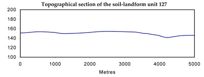
Soil/Landform Unit 127
Landform Unit Description
Page top
 Gilgai and cracking clays are fond on the plains and depressions. These soils support deep rooted perennial pasutres such as phalaris, cocksfoot and fescue |
1.35% of CMA region These gently undulating plains exist along the Corangamite and Glenelg-Hopkins catchment divide. The basalt plains are relatively young and have experienced little regolith and drainage development within the Western Plains. The plains have a wide array of land elements and derived soils. The most common soil types are the texture contrast soils on the rises. These soils vary in depth and may have a conspicuously bleached subsurface. Stone at the surface and as rock floaters also varies in concentration across the landscape. Friable red and black loams are found on crests and upper slopes while black and grey cracking clays are associated with depressions and the gilgai microrelief of this unit. Local relief is low with a sparse drainage network. The only significant vegetation class of these plains is the plains grassy woodland at 0.6%. This is a large unit with few outliers and is surrounded by other basaltic areas (including stony rises) to the north and east. This unit provides a western margin for unit 136. The land use is grazing (mainly sheep) with cropping on rock-free plains, slopes and depressions. Waterlogging is a major land degradation and productivity issue due to the low relief and impermeable nature of most soils. | 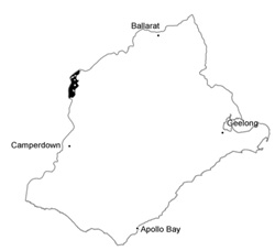 |
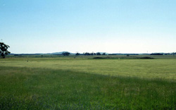
 Drainage is variable in pattern and reflects the diverse array of soils and surfaces of this unit | 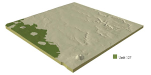 |
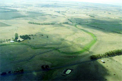
 | 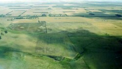 Stony rises and soils with many surface stone are common in this unit |
Component | 1 | 2 | 3 | 4 | 5 | 6 | 7 | 8 |
Proportion of soil-landform unit | 25% | 35% | 8% | 15% | 4% | 7% | 4% | 2% |
| CLIMATE Rainfall (mm) | Annual: 640 | |||||||
| Temperature (oC) | Minimum 8, Maximum 19 | |||||||
| Precipitation less than potential evapotranspiration | October-March | |||||||
| GEOLOGY Age and lithology | Quaternary basalt, minor clay, sand and gravel | |||||||
| Geomorphology | ||||||||
| LANDUSE | Uncleared: Nature conservation Cleared: Sheep and beef cattle grazing; cropping (cereal) on rock free land | |||||||
| TOPOGRAPHY Landscape | Gently undulating basalt plain | |||||||
| Elevation range (m) | 129-261 | |||||||
| Local relief (m) | 2-3 | |||||||
| Drainage pattern | Dendritic-sporadic | |||||||
| Drainage density (km/km2) | 0.5 | |||||||
| Landform | Undulating plains | Gentle rises (lacking surface stones) | Steeper rises (with surface stones) | Drainage depressions | ||||
| Landform element | Long gentle slopes | Plains | Crest, upper slopes | Long gentle side | Crestm upper slopes | Lower slopes | Valley flats | Swamps and depressions |
| Slope and range (%) | 2 (1-4) | 1 (0-2) | 4 (1-8) | 3 (2-6) | 6 (3-12) | 4 (2-6) | 0 (0-2) | 1 (0-3) |
| Slope shape | Straight | Straight | Convex | Straight | Convex | Straight | Straight | Concave |
| NATIVE VEGETATION Ecological Vegetation Class | Plains Grassy Woodland (0.6%) | |||||||
| SOIL Parent material | In situ basalt and colluvium | In situ basalt and colluvium | In situ basalt | In situ basalt and colluvium | In situ basalt | In situ basalt and colluvium | Colluvium and alluvium | Colluvium and alluvium |
| Description (Corangamite Soil Group) | Alkaline mottled brown, grey or yellow texture contrast soils (36) | Grey and black cracking clay soils (31) | ||||||
| Soil type sites | ||||||||
| Surface texture | Fine sandy clay loam | Fine sandy clay loam | Fine sandy clay loam | Fine sandy clay loam | Sandy loam | Fine sandy clay loam | Light clay | Light clay |
| Permeability | Low | Low | Low to moderate | Low | Moderate to high | Moderate | Very low | Very low |
| Depth (m) | <1.5 | <2 | <1.5 | <2 | <0.7 | <1 | >2 | >2 |
| LAND CHARACTERISTICS, POTENTIAL AND LIMITATIONS | Texture contrast, moderate water holding capacity and nutrient holding capacity in upper soil. Strongly sodic, low permeability subsoil, occasionally upper soil. Stone common along with some buckshot gravel. | Texture contrast, moderate water holding capacity and nutrient holding capacity in upper soil. Strongly sodic, low permeability subsoil, occasionally upper soil. Stone comon along with buckshot gravel. | Texture contrast, moderate water holding capacity and nutrient holding capacity in upper soil. Strongly sodic, low permeability subsoil, occasionally upper soil. Some stone and buckshot gravel. Slow to moderate site drainage. | Shallow, stony. Texture contrast or loamy. Sodic often strongly. Moderate to high permeability subsoil. Rapid site drainage. | Texture contrast, moderate water holding capacity and nutrient holding capacity in upper soil. Strongly sodic, low permeability subsoil, occasionally upper soil. Some stone and buckshot gravel. Slow to moderate site drainage. | Expansive clays, high water holding capacity and nutrient holding capacity. Strongly sodic, low permeability soil, occasionally upper soil. Minor stone. Slow to very slow site drainage. | Expansive clays, high water holding capacity and nutrient holding capacity. Strongly sodic, low permeability soil, occasionally upper soil. Slow to very slow site drainage. | |
© State of Victoria (Agriculture Victoria) 1996 - .

This work, Victorian Resources Online, is licensed under a Creative Commons Attribution 4.0 licence. You are free to re-use the work under that licence, on the condition that you credit the State of Victoria (Agriculture Victoria) as author, indicate if changes were made and comply with the other licence terms.
The licence does not apply to ‘branding’ or some ‘images or photographs’ that may be owned by third parties. We ask you to seek prior approval to use images using the VRO feedback form. Access to higher quality images can also be provided on request.
This page was last updated on .