
Soil/Landform Unit - Mount Cole Creek
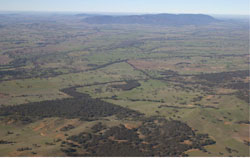 Mount Cole Creek and the Wimmera River converging west of Eversley |
0.87% of CMA region This unit is an alluvial valley complex associated with the upper Wimmera River and forms part of the alluvial terraces and floodplains subdivision (2.1.7) landscape of the Dissected Western Uplands. This alluvial unit is surrounded by many hilly to mountainous units including the Pyrenees Ranges, Mount Langi Ghiran and the Concongella hills from north to south. The alluvial plains/flats occur as elongated valleys that are confined by higher relief. Terrace plains and flats, gentle lower slopes, drainage depressions, valley flats and moderate upper slopes all occur within these valleys. Soil types are predominantly red sodic texture contrast soils (Sodosols) with yellow, brown and grey sodic gradational (Dermosols) and texture contrast soils (Chromosols), the latter in the depressions. Soil compaction is a potential land degradation susceptibility as is waterlogging on the depressions, broader flats and plains where topsoils are shallow. Fodder production and cereal cropping are common enterprises but grazing (sheep and cattle) is the dominant enterprise. Heathy Dry Forest and Grassy Forest vegetation communities are associated with exposed areas of the landscape, while Herb-rich Foothill Forest and Valley Grassy Forest are more associated with sheltered areas of the landscape. Other remnant vegetation include various woodlands. | 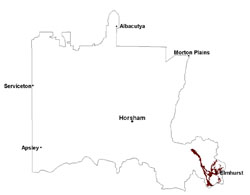 |
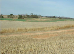 Alluvial terraces of the Wimmera River near Crowlands | 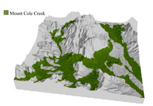 |
 | 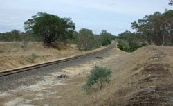 Terrace plain railway cutting and Mount Cole Creek |
Component | 1 | 2 | 3 | 4 | 5 | 6 | 7 |
Proportion of soil-landform unit | 12% | 20% | 23% | 10% | 5% | 23% | 7% |
| CLIMATE Rainfall (mm) | Annual: 640 | ||||||
| Temperature (oC) | Minimum 7, Maximum 19 | ||||||
| Precipitation less than potential evapotranspiration | October–April | ||||||
| GEOLOGY Age and lithology | Cambrian marine sandstone, siltstone and biotite schist (St Arnaud Group); Quaternary fluvial gravel, sand and silt; Devonian granite | ||||||
| Geomorphology | |||||||
| LANDUSE | Uncleared areas: water supply; nature conservation Cleared areas: sheep and beef cattle grazing; dryland cropping; pasture production; water supply | ||||||
| TOPOGRAPHY Landscape | Alluvial plain and valleys | ||||||
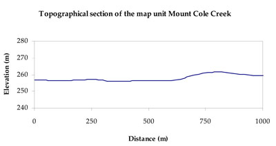
| Elevation range (m) | 201–840 | ||||||
| Local relief (m) | 5 | ||||||
| Drainage pattern | Dendritic | ||||||
| Drainage density (km/km2) | 1.6 | ||||||
| Landform | Alluvial terraces, plains and floodplains | Alluvial valleys | |||||
| Landform element | Gentle slope | Terrace plain | Terrace flat | Drainage depression | Moderate upper slope | Gentle lower slope | Valley flat |
| Slope and range (%) | 3 (1-6) | 2 (0-10) | 1 (0-2) | 2 (0-5) | 12 (10-30) | 5 (3-20) | 2 (1-10) |
| Slope shape | Straight | Straight | Convex | Straight | Concave | Convex | Straight |
| NATIVE VEGETATION Ecological Vegetation Class | Plains Woodland (18.4%), Creekline Grassy Woodline (13.6%), Alluvial Terraces Herb-rich Woodland (12.0%) | ||||||
| SOIL Parent material | In situ intrusive granite, marine sandstone, siltstone and biotite schist | Fluvial gravel, sand and silt | Fluvial gravel, sand and silt | Fluvial gravel, sand and silt | In situ marine sandstone, siltstone and biotite schist, intrusive granite | Alluvial gravel, sand and silt | Alluvial gravel, sand and silt |
| Description (Corangamite Soil Group) | Red texture contrast soils (10) | Red texture contrast soils (10) | Sodic brown, yellow and grey texture contrast soils (12) | Yellow and brown gradational and texture contrast soils (11) | Yellow and brown gradational and texture contrast soils (11) | Sodic brown, yellow and grey texture contrast soils (12) | |
| Soil type sites | |||||||
| Surface texture | Sandy loam | Sandy loam | Sandy loam | Loam, fine sandy (heavy) | Loamy sand | Loamy sand | Loam, fine sandy (heavy) |
| Permeability | High | High | High | Slow | High | High | Moderate to slow |
| Depth (m) | > 2 | > 2 | > 2 | > 2 | > 2 | > 2 | > 2 |
| LAND CHARACTERISTICS, POTENTIAL AND LIMITATIONS Critical land features, processes, forms | Light soil surface susceptible to sheet and rill erosion and compaction. Subsoil susceptible to rill and gully erosion where sodic. Lighter soil variants are well drainage. Upper soil susceptible to acidification. | Lighter surface susceptible to compaction and hardsetting with low organic matter levels. Soils are susceptible to sheet and rill erosion where slopes are steeper. Subsoil susceptible to rill and gully erosion. Lighter variants are well drained. | Light soil surface susceptible to sheet and rill erosion and compaction. Subsoil susceptible to rill and gully erosion where sodic. Lighter soil variants are well drainage. Upper soil susceptible to acidification. | Lighter surface susceptible to sheet and rill erosion and compaction. Subject to periodic inundation and waterlogging, especially during flood events. Lighter soil variants are well drained within the depressions. Upper soil susceptible to acidification. | Lighter surface susceptible to sheet and rill erosion and compaction. Subsoil susceptible to rill and gully erosion where sodic and deeper. Lighter variants are well drained. | Lighter surface susceptible to sheet and rill erosion and compaction, especially with low organic matter. Susceptible to rill and gully erosion where sodic subsoils are exposed. Lighter variants are well drained. | Lighter surface susceptible to sheet and rill erosion and compaction. Subject to periodic inundation and waterlogging, especially during flood events. Lighter soil variants are well drained within the depressions. Upper soil susceptible to acidification. |
© State of Victoria (Agriculture Victoria) 1996 - .

This work, Victorian Resources Online, is licensed under a Creative Commons Attribution 4.0 licence. You are free to re-use the work under that licence, on the condition that you credit the State of Victoria (Agriculture Victoria) as author, indicate if changes were made and comply with the other licence terms.
The licence does not apply to ‘branding’ or some ‘images or photographs’ that may be owned by third parties. We ask you to seek prior approval to use images using the VRO feedback form. Access to higher quality images can also be provided on request.
This page was last updated on .