
Sandy Soils
|
This map presents a broad overview of the distribution of sandy soils in the Wimmera region. A number of soil surveys have been done in this region (see Soil and Land Survey Directory) at varying scales and intensity. In some areas very little soil survey has taken place. This map therefore provides a broad indication only of the distribution of sandy soils in the Wimmera region.
|
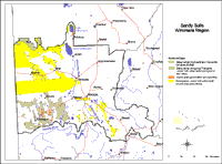
There are a wide variety of sandy soils in the Wimmera region. Some of these soils are sandy throughout the profile and can be quite deep. Other soils can have a deep sandy surface layer overlying a clayey subsoil. A deep sandy surface horizon is considered here to be at least 30 cm in depth. In cases where there is a sandy surface horizon overlying a sodic clay subsoil, then these soils will also be considered as Sodosols.
Deep Sandy Soils
The pale aeolian sands in the Big Desert region originated as coastal sands when the inland seas retreated westwards from the Murray Gulf in the Tertiary period. They are usually associated with the high parabolic shaped dunes, apparently formed in geologically recent periods of wind activity. There is often little soil development apart from surface accumulation of organic matter. These loose white sands have low fertility and a high wind erosion hazard. They are, however, well drained. These soils are generally referred to as Rudosols in the Australian Soil Classification. As well as occurring in the Big Desert, these soils can also occur further south.
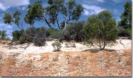
Deep bleached sands overlying Tertiary (Parilla) sandstone near Telopea Downs.
In some parts of the landscape (although more common in the Mallee region) are areas of land with east-west trending dunes. These soils are sandy throughout with a dark surface horizon overlying a strongly bleached subsurface horizon and a brighter coloured sandy subsoil horizon (which is usually slightly harder than the surface horizons and may also have clay banding). These soils can vary between moderately deep to very deep (ie. 1-6 metres) and are generally referred to as Tenosols in the Australian Soil Classification (being better developed than Rudosols). These soils are associated with sand dunes and sand hills which are commonly found on the undulating sand plains west of Dimboola (ie. Little Desert) and north of Nhill and Kaniva (Big Desert). They also occur on many of the dissected sand dunes which are scattered on the undulating plains west of Natimuk. These soils also occur in association with Sandy Sodosols.
These soils are characterised by:
- Profiles which are sandy throughout
- Lack of soil structure
- Soft soil surface (non hardsetting) which may be difficult to wet (‘non-wetting’)
- Subsoil horizons which usually have a brighter colour than the surface soil horizons
- Acidic soil profile throughout
- Poor soil fertility and low water holding capacity
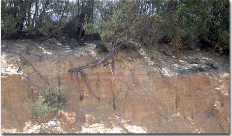
Tenosol near Telopea Downs. Note the development of clayey bands in the subsoil.
Podosols
These are strongly leached sandy soils which are poor in nutrients and acidic to strongly acidic throughout. They are characterised by having variably cemented iron and humus accumulations in the subsoil (often referred to as ‘coffee rock’). They have a low water holding capacity and are well drained (although deeper drainage may be restricted by the ‘coffee rock’ layer).
Texture Contrast soils (sands over clay subsoils)
These soils are commonly found on sand sheets, low dunes and hill slopes and may occur in association with the deeper sands. They are characterised by surface horizons (30 cm or greater in depth) overlying a clay subsoil. The upper subsoil is mainly yellow to grey in colour (often mottled), coarsely structured (columnar or prismatic) and often sodic. In lower lying positions, waterlogging can occur above the slowly permeable subsoils.
In cases where a sodic subsoil occurs, then these soils are technically referred to as Sodosols and may therefore also be shown on the Sodosols map.
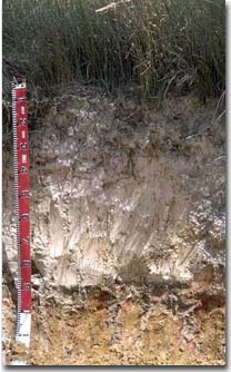
Sandy surface horizons overlying sodic clay subsoil.
© State of Victoria (Agriculture Victoria) 1996 - 2025.

This work, Victorian Resources Online, is licensed under a Creative Commons Attribution 4.0 licence. You are free to re-use the work under that licence, on the condition that you credit the State of Victoria (Agriculture Victoria) as author, indicate if changes were made and comply with the other licence terms.
The licence does not apply to ‘branding’ or some ‘images or photographs’ that may be owned by third parties. We ask you to seek prior approval to use images using the VRO feedback form. Access to higher quality images can also be provided on request.
This page was last updated on 25/01/2019.