Sodosols
Sodosols are soils which display a strong texture contrast between surface (A) horizons and subsoil (B) horizons which are sodic. Using the Australian Soil Classification, Sodosols can be grouped further based on the colour of the upper 20 cm of the subsoil (ie. Red, Brown, Yellow and Grey). These can then be further differentiated based on subsoil characteristics such as level of sodicity and presence of carbonate (lime).
Sodosols in the Wimmera region occur on a wide range of landforms (from gently undulating plains and rises to undulating low hills). Surface soil textures and depths vary considerably and have significant implications for management; affecting soil workability and permeability, crop establishment, moisture availability and erodibility. The subsoils are sodic and are generally quite dense and coarsely structured (characterised by coarse prismatic, columnar or blocky peds), and disperse when wet - resulting in restricted root and water movement through the profile.
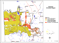
 Sodosols in the Wimmera Region | This map presents a broad overview of the distribution of Sodosols in the Wimmera region. A number of soil surveys have been done in this region (see Soil and Land Survey Directory) at varying scales and intensity. In some areas very little soil survey has taken place. This map therefore provides a broad indication only of the distribution of Sodosols in the Wimmera region. |
| It is a broadscale map and should be used as a general indication only of the distribution of Sodosols in the Wimmera region. Soils are difficult to map at this broad scale because of their diversity. Even in relatively small areas, a number of soils may occur which relate to differences in topography and landscape position. Variation in some of the major soil profile properties can also occur within these mapped areas. Any cropping enterprise should be based on a proper on-site assessment of the soil and landscape. | |
Hardsetting Red Sodosols
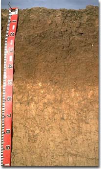
 Red Sodosol near Kaniva. | The hardsetting Red Sodosols usually occur on the gently undulating plains and rises north of the Little Desert (Nhill and Kaniva region) and in the eastern parts of the region (west of Charlton region). Minor occurrences can be found associated with Vertosols north of Horsham where they occur on higher landscape positions. The surface soil is usually a grey-brown to reddish brown sandy loam to clay loam and slightly acid. A subsurface (A2) horizon may or may not be present. When present, it may not be bleached, sporadically bleached or conspicuously bleached. The upper clayey subsoil (B) horizon is red to reddish brown and sodic. The deeper subsoil can become yellower, and may contain various amounts of soluble salts and carbonate (lime) segregations. The deeper subsoils are often alkaline to strongly alkaline. Red Sodosols are generally hard-setting when dry; tend to seal and crust after rain; become cloddy when cultivated; and are not gilgaied. Gypsum is commonly used as an ameliorative technique to combat soil sodicity and improve water penetration into these soils as well as seedling emergence. Root and water movement in the subsoil can also be improved. The addition of gypsum to sodic soils, together with conservation farming practices to build up organic matter in the surface soil are recommended to improve soil structure. Minimum tillage/cultivation will also prevent further structural degradation occurring. |
Sodosols with sandy surface horizons
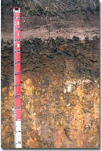
 Brown Sodosol near Nhill. Note bleached subsurface horizon and columnar structure in upper subsoil. | Sodosols with shallow or deep sandy surface soils are common in the Wimmera region where they are usually found on sand sheets, dunes and hill slopes. They are commonly found to the west of the Wimmera River and are usually associated with deeper bleached sands. These soils are characterised by a dark surface (A1) horizon which ranges from sand to sandy loam in texture. The surface soil may or may not be hardsetting. A paler subsurface (A2) horizon underlies the surface soil. It is usually strongly bleached and commonly sand to loamy sand in texture. These horizons can range from 10 to 50 cm in thickness. A clear to abrupt boundary occurs to the clayey subsoil. The subsoils are often light brownish grey to yellowish brown with yellow and red mottles and usually dense and coarsely structured. Subsoils are typically prismatic or columnar in structure. Sandy surface soils often have low levels of nutrients and lower water storage capacity, but are relatively easy to work. In some instances the dry sand surfaces are water repellent making it difficult to soak up moisture. The bleached subsurface (A2) horizons can be quite thick (up to 50 cm) and have a very low inherent fertility. After heavy rains water will build up on the slowly permeable subsoils and the subsurface (A2) horizon will become saturated. |
Soil Management Issues
- Frequent cultivation on hardsetting Red Sodosols can have a deleterious effect on soil structure, increasing erodibility, compaction or resulting in aggregate breakdown. Reduced cultivation and residue retention have been shown to improve soil structure and result in improved water infiltration and more favourable seedbed conditions.
- Sodic soils often exhibit poor soil surface structure which can result in poor plant emergence, waterlogging and ponding, and are often difficult to work when wet or dry. Some surface soils may disperse and seal when wet and become hardsetting and crusty when dry. This can result in reduced crop yields due to reduced water infiltration and restricted plan emergence. Surface sealing reduces crop emergence and restricts entry of water into the soil. Reduced cultivation and/or stubble retention assists formation of aggregates by maintaining higher organic matter levels and protecting the soil from rain drop impact. Gypsum will have an ameliorative effect on soil sodicity and also dispersion.
- A field test to measure amounts of dispersion has recently been developed by the Cooperative Research Centre for Soil and Land Management in Adelaide and is described in the publication: ‘Managing Sodic, Acidic and Saline Soils’. Also, the State Chemistry Laboratory in Werribee offers an analytical service for measuring soil sodicity and dispersion.
- The surface soil aggregates are often unstable and slake when wet. Dispersion may also occur. When dry the surface soil sets hard and become difficult to work. The moisture range at which these soils can be easily worked without causing structural degradation is very narrow. For much of the year the soil is either too wet or too dry to cultivate. Gypsum can help improve this situation. Crop establishment can become difficult if heavy rain falls after sowing but before emergence, causing surface sealing and compaction which restricts crop emergence or causes un-germinated seed to rot. When cultivated dry, the surface soil can become ‘powdery’ and more readily erodible by wind. Timing cultivation at the correct soil moisture and reducing frequency and speed of working reduces resultant soil structural damage.


