
Inverloch (In)
Geology Mostly Tertiary sediments, some Early Pleistocene sediments. Landform Undulating rises. Soils The soils are similar to those occurring on Leongatha South mapping unit. However, they are separated in that they are slightly higher in elevation and overall relief and areas of coarse sandy and gravelly soils are often present. |  |
Apart from soils in drainage depressions (Component 4) the surface soils range from very dark grey clay loams to gravelly loams and occasionally loamy sand. This overlies a light grey or light brownish grey similarly textured subsurface soil at about 20 cm. Below the bleached zone the subsoils are quite variable. As in the case of the Leongatha South mapping unit, it is convenient to separate the soils into three components (Components 1, 2 & 3) on the basis of subsoil differences but at the present scale of mapping it is not possible to separate them on the soil map.
Component 1
Clays occur immediately below the bleached zone. These range from sandy clay to heavy clays and occur from about 50 to 70 cm. Generally they are mottled light grey and yellowish brown.
| Component 2 At about 40 to 50 cm and below the bleached zone, the subsoil changes clearly to a light brownish grey or greyish brown, mottled with yellowish brown sandy clay which is often difficult to penetrate with the soil auger. Mottled light greyish brown or yellowish brown sandy clays to heavy clays occur from about 80 cm. Sandstone may occur below 1.5 m. Soil Site SG2 is an example of a Grey Kurosol within this mapping unit. A "coffee rock" layer occurs below the bleached subsurface (A2) horizon. The zone below the coffee rock layer is indurated (hardened) and overlies a structured deeper subsoil. This soil is typical in Component 2 of this mapping unit. Component 3 A zone of variably cemented "coffee rock" occurs below the bleached zone at about 40 or 50 cm. Colours vary, but they are predominantly dark grey and strong brown. Below the "coffee rock" light grey and yellowish brown variably cemented sandy clay loams to sandy clays occur, which in turn overlie similarly coloured sandy clay to heavy clay. Soil Site SG8 is an example of a Semiaquic Podosol that occurs in this mapping unit. | 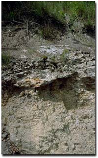 Road cutting between Wonthaggi and Bald Hill showing the indurated (hardened) zone near the top of the profile. |
The soils in the drainage depressions occupy less than 10% of this mapping unit. Insufficient information has been recorded to give a reliable description of this component.
Occurrence
The Inverloch mapping unit is widespread on the Tertiary sediments throughout west and south Gippsland.
© State of Victoria (Agriculture Victoria) 1996 - 2025.

This work, Victorian Resources Online, is licensed under a Creative Commons Attribution 4.0 licence. You are free to re-use the work under that licence, on the condition that you credit the State of Victoria (Agriculture Victoria) as author, indicate if changes were made and comply with the other licence terms.
The licence does not apply to ‘branding’ or some ‘images or photographs’ that may be owned by third parties. We ask you to seek prior approval to use images using the VRO feedback form. Access to higher quality images can also be provided on request.
This page was last updated on 25/01/2019.