SG8
| Location: Middle Tarwin | Australian Soil Classification: Melacic-Parapanic, Humic/Humosesquic, Semiaquic PODOSOL (f. Grey KUROSOL1). |
| Great Soil Group: humus podzol | Geology: Tertiary sediments. |
| General Landscape Description: Elevated plateau on a gently undulating rise (slope <3%). | Soil Mapping Unit: Inverloch. |
| Site Description: Bushland Reserve. | Native Vegetation: Includes Messmate (Eucalyptus obliqua) and Brown Stringybark. |
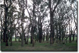 Site SG8 Landscape |
Soil Profile Morphology:
Surface Soil
| A1 | 0-20 cm | Black (10YR2/1); fine sandy loam; very weak fine blocky structure; firm surface condition; firm consistence dry; contains a few (5%) quartz gravels (2-3 mm diameter); pH 4.9; clear change to: | 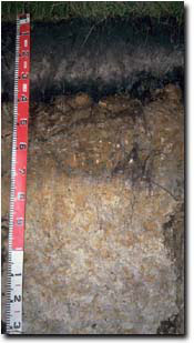 Site SG8 Profile |
| A2 | 20-30 cm | Pinkish grey (7.5YR6/2); fine sandy loam; structureless; strong consistence dry; contains many (25%) quartz gravels (2-5 mm diameter); dark staining in patches; pH 4.8: abrupt and wavy change to: | |
| Subsoil | |||
| Bh | 30-40 cm | Black (10YR2/1); loam; moderate very fine crumbly polyhedral structure; firm consistence dry; pH 4.7; sharp change to: | |
| Bhs | 40-65 cm | Variably cemented coffee rock material; pH 5.1; sharp change to: | |
| D21 | 65-75 cm | Light brownish grey (10YR6/2) with yellowish brown (10YR5/6) mottles; light clay (gritty); strong fine polyhedral structure; weak consistence moist; contains a common (15%) amount of quartz gravel (2-4 mm diameter); pH 4.8; clear change to: | |
| D22 | 75-95 cm | Light grey (10YR7/1) with yellowish brown (10YR5/6) mottles; heavy clay (kaolinitic); flaky structure; very firm consistence moist; pH 4.5; gradual change to: | |
| D23 | 95+ cm | White (10YR8/1) with yellowish brown (10YR5/6) mottles; heavy clay (kaolinitic); flaky structure; very firm consistence moist; pH 4.4. | |
1 It appears that the Podosol is forming in the A horizon of an older Grey Kurosol. | |||
Key Profile Features:
- Subsoil accumulation of organic matter humic layer (30 - 40 cm) and organic matter/iron coffee rock (40-65 cm).
Soil Profile Characteristics:
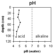 | The pH is very strongly acid throughout most of the profile and becomes extremely acid at approximately one metre depth. | 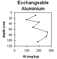 | Exchangeable aluminium levels are high throughout most of the soil profile. |
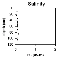 | The soluble salt levels are very low throughout the soil profile. | 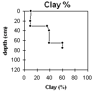 | The clay content increases markedly from the surface horizons to the cemented coffee rock and then to the D horizons. |
Horizon | Horizon Depth (cm) | pH (water) | pH (CaCl2) | EC 1:5 | Exchangeable Cations | |||
Ca | Mg | K | Na | |||||
meq/100g | ||||||||
A1 | 0-20 | 4.9 | 3.9 | 0.06 | 1.7 | 0.8 | 0.2 | 0.1 |
A2 | 20-30 | 4.8 | 4.0 | <0.05 | 0.2 | 0.3 | 0.1 | <0.1 |
Bh | 30-40 | 4.7 | 3.9 | 0.09 | 0.5 | 1.9 | 0.1 | 0.3 |
Bhs | 40-65 | 5.1 | 4.7 | 0.08 | 0.1 | 0.2 | 0.1 | 0.1 |
D21 | 65-75 | 4.8 | 4.2 | 0.09 | 0.1 | 0.5 | 0.1 | 0.1 |
D22 | 75-95 | 4.5 | 4.0 | 0.12 | 0.1 | 0.6 | 0.1 | 0.1 |
D23 | 95+ | 4.4 | 3.8 | 0.08 | 0.1 | 0.6 | 0.1 | 0.1 |
Horizon | Horizon Depth (cm) | Exchangeable Aluminium mg/kg | Exchangeable Acidity meq/100g | Field Capacity pF2.5 | Wilting Point pF4.2 | Coarse Sand (0.2-2.0 mm) | Fine Sand (0.02-0.2 mm) | Silt (0.002-0.02 mm) | Clay (<0.002 mm) |
A1 | 0-20 | 170 | 20.2 | 30 | 8 | 18 | 37 | 26 | 10 |
A2 | 20-30 | 97 | 6.2 | 14 | 3 | 24 | 39 | 28 | 9 |
Bh | 30-40 | 200 | 45.8 | 33 | 19 | 13 | 22 | 7 | 36 |
Bhs | 40-65 | 150 | 38.6 | 10 | 14 | 12 | 39 | ||
D21 | 65-75 | 270 | 19.8 | 9 | 15 | 11 | 60 | ||
D22 | 75-95 | 260 | 12.4 | 8 | 18 | 11 | 60 | ||
D23 | 95+ | 190 | 12.4 |
Management Considerations:
Whole Profile
- Plant Available Water Capacity (PAWC) is considered to be very low (estimated at approximately 45 mm). This is based on available laboratory data and assumes an effective rooting depth of 40 cm. Rooting depth is likely to be limited by the "coffee rock" layer that begins at 40 cm depth.
- The presence of a subsoil humic layer (30 - 40 cm) indicates the soil profile is likely to suffer at least some short-term saturation of the B horizons.
- In the strongly acid surface horizon, the level of exchangeable aluminium measured in the laboratory is high (170 mg/kg). This is likely to restrict the growth of a number of aluminium sensitive species such as lucerne, medics, phalaris, subclover, white clover and tall fescue.
- Deficiencies in molybdenum, phosphorus and potassium may occur in the very strongly acid surface soil. Raising the soil pH by lime application will enable phosphorous (from superphosphate application) to be more readily available. Liming is likely to improve pH and aluminium levels in the surface soil. Plant tissue analysis may give a more accurate assessment of molybdenum trace element requirements.
- Root and water movement is likely to be restricted by the "coffee rock" layer at 40 cm.


