
Kurosols
Kurosols have a strong texture contrast between loamy surface (A) horizons and clayey subsurface (B) horizons. The subsoils are strongly acid (i.e. pH 5.4 or lower). Kurosols can be separated on the basis of the colour of the upper 20 cm of the subsoil into Red, Brown, Yellow, Grey and Black groups. Further separation is largely made on the basis of additional soil chemical properties.
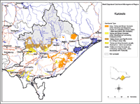 Kurosols in the West Gippsland Region |
|
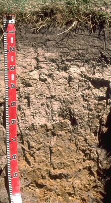 Brown Kurosol near Fish Creek. |
Kurosols generally occur in higher rainfall parts of the region and have largely developed on Palaeozoic sediments with some on the Cretaceous and Tertiary sediments. |
© State of Victoria (Agriculture Victoria) 1996 - 2025.

This work, Victorian Resources Online, is licensed under a Creative Commons Attribution 4.0 licence. You are free to re-use the work under that licence, on the condition that you credit the State of Victoria (Agriculture Victoria) as author, indicate if changes were made and comply with the other licence terms.
The licence does not apply to ‘branding’ or some ‘images or photographs’ that may be owned by third parties. We ask you to seek prior approval to use images using the VRO feedback form. Access to higher quality images can also be provided on request.
This page was last updated on 25/01/2019.