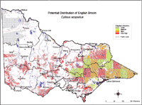
Potential Distribution of English broom (Cytisus scoparius) in Victoria (Nox)
| Potential distribution produced from CLIMATE modelling and overlayed on suitable landuses with CMA boundaries. Overlays used Mean pH of soils: pH between 5.0 -7.0 RMU_units: Alpine Vegetation types: Shrub/ Heathland, Open Forest and Woodland Hydrology: Main water courses Colours indicate possibility of C. scoparius infesting these areas. In the non-coloured areas the plant is unlikely to establish as the climate, soil or landuse is not currently suitable. Further information on mapping potential distribution of weeds | |


