
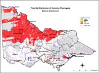
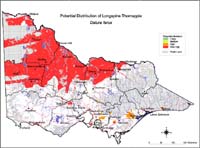
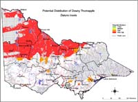
Potential Distribution of Thorn apples (Datura spp.) in Victoria (Nox)
| This map of the potential distribution of Common Thorn Apple, Longspine Thorn Apple and Downy (Recurved) Thorn Apple has been produced from CLIMATE® modelling overlayed with: Overlays used Land Uses: Pasture irrigated and dryland Horticulture Broadacre cropping Broad vegetation types: Riverine grassy woodland; and riparian forest. Colours indicate possibility of Datura spp. infesting these areas. Red = Very High Orange = High Light Green = Medium Dark Green = Likely In the non-coloured areas the plant is unlikely to establish as the climate, soil or landuse is not presently suitable. Further information on mapping potential distribution of weeds | |
© State of Victoria (Agriculture Victoria) 1996 - .

This work, Victorian Resources Online, is licensed under a Creative Commons Attribution 4.0 licence. You are free to re-use the work under that licence, on the condition that you credit the State of Victoria (Agriculture Victoria) as author, indicate if changes were made and comply with the other licence terms.
The licence does not apply to ‘branding’ or some ‘images or photographs’ that may be owned by third parties. We ask you to seek prior approval to use images using the VRO feedback form. Access to higher quality images can also be provided on request.
This page was last updated on .