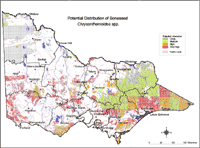
Potential Distribution of Boneseed / Bitou bush (Chrysanthemoides monilifera) in Victoria (Nox)
| Potential distribution produced from CLIMATE modelling and overlayed on suitable landuses with CMA boundaries. Overlays used Vegetation types: Closed Forest, Open Forest, Mallee Complex, Shrub/heathland, Woodland Land use: Forest Private Plantation, Forest Public Plantation | |
| Colours indicate possibility of Chrysanthemoides monilefera infesting these areas. In the non-coloured areas the plant is unlikely to establish as the climate, soil or landuse is not currently suitable. Further information on mapping potential distribution of weeds | |


