
Present Distribution of Gorse (Ulex europaeus) in Victoria (Nox)
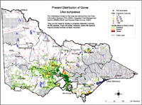 Present Distribution of Gorse | The infestations shown on this map are derived from the Flora Information Systems (FIS) (2002) and Integrated Pest Management System (IPMS) (2003) and Noxious Weed Survey (Lane et al, 1980). The map is not meant to display a complete statewide inventory for this species. There are areas, for instance, where this species may be present but has not been recorded. IPMS data, for example, reflects the regional policies, priorities, programs and available human resources etc over the last 12 or so years (up to early 2003). It is reasonable, therefore, to assume that for most species, the extent of infestations in a region will be greater than is recorded. |
Information from Noxious Weeds Survey (Lane et al 1980)
| Colour | Infestation | Area (ha) |
| Red | Dense Infestation | 40,000 |
| Yellow | Medium | 103,000 |
| Orange | Scattered | 805,000 |
| Total | 948,000 |
© State of Victoria (Agriculture Victoria) 1996 - 2025.

This work, Victorian Resources Online, is licensed under a Creative Commons Attribution 4.0 licence. You are free to re-use the work under that licence, on the condition that you credit the State of Victoria (Agriculture Victoria) as author, indicate if changes were made and comply with the other licence terms.
The licence does not apply to ‘branding’ or some ‘images or photographs’ that may be owned by third parties. We ask you to seek prior approval to use images using the VRO feedback form. Access to higher quality images can also be provided on request.
This page was last updated on 18/08/2020.