
5.3.3 Linear depression (Douglas Depression)
5. North Western Dunefields and Plains (DP)
5.3 Depressions
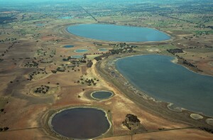
| This third tier sub-division consists one large continuous depression unit located in Western Victoria; one of the most southerly occurrences of the Dunefields and Plains Division (Tier 1; 5). The northern boundary is with the Little Desert (5.2) and the Wimmera River (4.1) whose broad valley forms a continuing Depression link to Depression units further north. The Depression is at its widest here, about 8-9km across decreasing in width further south. To the west of the Depression and to some extent to the east lies a complex of ridges and depressions, the ridges often subdued (5.5.2). The degree and clarity of incision of the Depression in the landscape varies, probably most defined by its deflection around Mt Arapiles (5.6), an inlier of the Grampians sandstone complex. The Depression is dominated by a series of lakes, of which most are saline and to the south where the Depression width varies from 2-3 km and wider (4-5 km) to the south of Douglas with the larger lakes e.g. White Lake. The Depression peters out surficially (after about 85 km from the Wimmera River) to the south of White Lake on encountering the Tablelands (2.3), which rise gently to the south before being dissected by the Glenelg River. | 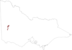 |
The Depression is an area of saline discharge as evidenced by the lake systems (often with lunette formations) and varying periods of water present and is likely to be structually controlled. The depth and age of regolithic material in the depression is not well known. It should be noted that similar formations of stranded beach ridges occur on both sides of the Depression (the ridges were formed approximately 4 mya). There is an incursion of Lowan Sand across the Depression to the north of Douglas, somewhat masking the Depression and the older ridge material. There is speculation, given the sharp flow direction change of the Wimmera River that the Depression is a paleochannel of a south to north flowing stream or indeed a north-south stream before the uplift (doming) of the Dundas Tablelands (2.3); some form of river capture has taken place. Another theory is that this was an outlet for a palaeo lake (Lake Bungunnia) as the inland sea of the Murray Basin retreated.
The Depression is an extention of what is known as the Lowan Salt Valley. The climate becomes milder and moister south of the Little Desert so that the calcareous soils and mallee vegetation start to disappear southwards; the Lowan Salt Valley is the most southerly incursion of Mallee type environment into the Riverine environment further south. The Douglas Depression has a range of soils from calcareous earths (Calcarosols) in the north to sodic and saline texture contrast (Sodosols) and cracking clay soils (Vertosols) to the south and amongst the lakes and swamps.
© State of Victoria (Agriculture Victoria) 1996 - .

This work, Victorian Resources Online, is licensed under a Creative Commons Attribution 4.0 licence. You are free to re-use the work under that licence, on the condition that you credit the State of Victoria (Agriculture Victoria) as author, indicate if changes were made and comply with the other licence terms.
The licence does not apply to ‘branding’ or some ‘images or photographs’ that may be owned by third parties. We ask you to seek prior approval to use images using the VRO feedback form. Access to higher quality images can also be provided on request.
This page was last updated on .