
5. North Western Dunefields and Plains (DP)
Victoria's Geomorphological Framework (VGF)
5.1 Calcareous dunefields
5.2 Siliceous dunefields (Sunset, Big and Little Desert)
5.3 Groundwater discarge depressions and palaeolacustrine plains
5.4 Clay plain with subdued ridges (Minyip)
5.5 Ridges with sand, and flats (Goroke, Nhill)
5.6 Hills and low hills (Mt Arapiles, Mitre rock, Mt Jeffcott)
5.7 Modern floodplains within dunefields
5.8 Older alluvial plains within dunefields
| The North Western Dunefields and Plains occur in the western part of the Murray Basin Plains submerged by Late Tertiary seas. Landscapes reflect diverse processes, including marine shoreline deposition, earth movements, lacustrine and alluvial deposition, accession of calcareous loess from coasts further to the west, groundwater discharge and finally dune development during Quaternary arid periods. Our understanding of the nature and distribution of the diverse landforms is being greatly enhanced by satellite images, particularly those showing elevation. The undulating landscapes are clearly defined from the Western Uplands to the south and from the Riverine Plains to the east. Riverine Plains also occur to the north along the River Murray, and in the south along several ephemeral stream courses which terminate in the central parts. Elevations decline from about 200 metres in the south to 40 metres in the north. The climate is mainly semi-arid, but it ranges from almost arid in the north to sub-humid in the south. Drainage systems have rarely been developed in the drier areas where rainfall is readily absorbed by porous soils. The centre and north are known as the Mallee after the growth form of the local multi-stemmed eucalypts. In the Wimmera the original vegetation was mostly grassy woodlands of eucalypts and Buloke (Allocasuarina leuhmannii). | 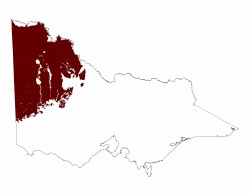 |
The whole area was inundated when sea levels rose about 6mya, depositing Parilla Sand. As the sea retreated westwards over a period of some 4 my, it built up a regular series of curvilinear beach ridges which trend NNW-SSE, tending to NW-SE in the north and N-S in the south. The stranded beach ridges and intervening swales were then laterised, producing soils some metres deep, with deep sands of low fertility overlying somewhat clayey subsoils, mottled zones of iron oxide segregation and accumulations of rounded or angular ironstone. The strandline ridges may be 50 kilometres or more long, usually about 3 kilometres across and 30 metres high.
Earth movement to the north west of the Pinnaroo Block dammed back the River Murray some 2.5 million years ago forming a huge lake system, Lake Bungunnia. Large lakes occupied the broad depressions, eroding and burying the strandline ridges. Lacustrine deposits, mainly grey clays (Blanchetown Clay) may be more than 30 metres thick in the major depressions. Bores have revealed their presence in most of the Victorian Mallee except to the south –east of Lake Tyrrell, in the Noora Depression and beneath much of the Big, Little and Sunset Deserts, three east-west belts of land which continue into South Australia. Blanchetown Clay has been noted to occur discontinuously beneath about half of the Wimmera, mostly towards the west.
Blancehtown Clay was overlain by Bungunnia Limestone as the lakes dried up. These two materials frequently form terraced plains which occur widely in the western parts of the Raak Depression and the northern part of the Tyrrell Depression. Alluvial and aeolian deposition also occurred during the Pleistocene. The alluvial Shepparton Formation accumulated mainly along streams entering the region from the south east.
During the last 500 Ka, a series of arid phases led to the widespread development of dunefields. The lacustrine, aeolian and alluvial deposits gave rise to the Woorinen Formation, calcareous material of variable clay content on which linear dunefields are prominent. Where laterised Parilla Sand remained at the surface, erosion produced Lowan Sand, the siliceous sand of the Big, Little and Sunset Deserts which contain both linear and parabolic dunes.
Our understanding of the nature and distribution of the diverse landforms is being greatly enhanced by datasets produced by modern technologies such as digital elevation models, radiometrics and satellite imagery.
The North Western Dunefields and Plains have been divided into 7 second tier geomorphic units: Calcareous dunefields, Siliceous dunefields, Groundwater discharge depressions and palaeolacustrine plains, Clay plains with subdued ridges, Ridges with sand and flats, Hills and low hills, Modern floodplains and Older alluvial plains.
Conn, B.J. 1993. Natural Regions and Vegetation of Victoria. In Flora of Victoria, Vol 1, Eds Foreman, D.B. and Walsh, N. G. Royal Botanical Gardens, Melbourne, Inkata Press.
Lawrence, C. R. 1976 Murray Basin. In Douglas, J. G. and Ferguson, J. A. eds. Geology of Victoria, pp 276-288. Geological Society of Australia Special Publication 5.
Wetherby, K. G. 1980. Shallow stratigraphy and dryland use of the Northern Murray Mallee, South Australia. In Aeolian Landscapes in the semi-Arid Zone. Australian Society of Soil Science Publication.
© State of Victoria (Agriculture Victoria) 1996 - 2025.

This work, Victorian Resources Online, is licensed under a Creative Commons Attribution 4.0 licence. You are free to re-use the work under that licence, on the condition that you credit the State of Victoria (Agriculture Victoria) as author, indicate if changes were made and comply with the other licence terms.
The licence does not apply to ‘branding’ or some ‘images or photographs’ that may be owned by third parties. We ask you to seek prior approval to use images using the VRO feedback form. Access to higher quality images can also be provided on request.
This page was last updated on 03/12/2020.