
5.2 Siliceous dunefields (Sunset, Big and Little Desert)
5. North Western Dunefields and Plains (DP)
5.2.1 - Parabolic dunes and sandplains (dominant in west and central Big Desert)
5.2.2 - Linear dunes and sandplains (Little Desert, Sunset Desert and eastern Big Desert)
| Weathered Parilla Sand was redistributed during Quaternary arid periods to form the Lowan Sand of the siliceous dunefields which contain both linear and sub-parabolic dunes. The weathered Parilla sand escaped burial by lacustrine and fluviatile sediments in elevated areas, particularly on broad tectonic ridges such as the Pinaroo Block and the Millewa Ridge. These ridges appear to be the prime sources of Lowan Sand derived by wind stripping of the deep sands on the laterised profiles. The dunefields have migrated eastwards for great distances, for example from the Sunset Strip across a depression underlain by Blanchetown Clay for a distance of some 80 km. Three clearly-defined tracts of Lowan Sand, the Big Desert, the Little Desert and the Sunset Desert extend eastwards from South Australia. The smallest, the Little Desert is about 25 km wide, and extends as far as the Wimmera River. The largest, the Big Desert, is almost 100 km wide along the border, narrowing towards the east. To the east of Outlet Creek and the Wirrengren Plain which marks the termination of the Wimmera River, the Big Desert splits into two arms enclosing calcareous dunefields. The northern arm reaches almost to Lake Tyrrell. The Sunset Desert, 35 km wide at the border, also narrows towards the east where it almost reaches the Hattah Lakes. | 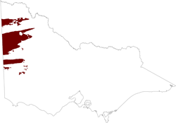 |
We have detected that the browser used to view this content is missing the supported 'Flash Player plugin'. You need to install the Adobe Flash Player to see this video
![]()
Once you have installed the 'Flash Player plugin' found on the Adobe website, please return to this web page by using the back button on your browser.
| Click the 'play' button and the video should display directly in your browser if this does not happen you may need to update the 'Adobe Flash Player'. This free software can be downloaded from the Adobe website (external link). |
Within all three areas there is a complex alternation of sub-parabolic and linear dunefields, mostly aligned in east-west belts with clear boundaries between them. Linear dunefields occupy most of the Little Desert. Parabolic dunes predominate in the Big Desert except to the east of the Wimmera River system where they are absent. Linear dunefields are a little more common in the Sunset Desert.
The parabolic dunefields appear to have developed by partial erosion of linear dunefields. The arms of the parabolic dunes are aligned south west – north east, the dominant direction of present day strong winds. Dunes in southern Victoria with similar orientation have been related to the modern wind regime. Weaker soil development also suggests that the parabolic dunefields are younger. Their soils lack development other than accumulation of surface humus, whereas in the linear dunefields B horizons are quite well developed. Unlike the Woorinen Formation, there is little detailed information on soil development in relation to erosional history in the Lowan Sand.
Stranded ridges are prominent in the Little Desert, mostly subdued in the Big Desert except in the south-west and to the east of the Wirrengren Plain, and not apparent in the Sunset Desert except on the Millewa Ridge. The Shepparton Formation, mostly clayey, was deposited between low-lying ridges, but is almost entirely covered by Lowan Sand. These sands overlie Blanchetown Clay in depressions. The Sunset Desert crosses the Noora Depression in the west and the Raak Depression in the east. The Big and Little Deserts cross the valley occupied by the Wimmera River. The deserts also overlie the Woorinen Formation near their margins.
The deserts remain largely uncleared because of low fertility and high erosion hazard. Most parts have become nature reserves, the Little Desert, Wyperfield and Murray Sunset National Parks, and the Big Desert Wilderness.
| References Hills, S.M. and Bowler, J. M. 1995. Linear dunes at Wilson’s Promontory and south-east Gippsland, Victoria: relict landforms from periods of past aridity. Proc. Royal Soc. of Victoria. Vol 107, pp 73-81 Related information on VRO
| 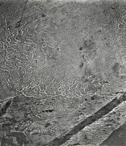 Silicous dunefields - 1963 air photo |
© State of Victoria (Agriculture Victoria) 1996 - .

This work, Victorian Resources Online, is licensed under a Creative Commons Attribution 4.0 licence. You are free to re-use the work under that licence, on the condition that you credit the State of Victoria (Agriculture Victoria) as author, indicate if changes were made and comply with the other licence terms.
The licence does not apply to ‘branding’ or some ‘images or photographs’ that may be owned by third parties. We ask you to seek prior approval to use images using the VRO feedback form. Access to higher quality images can also be provided on request.
This page was last updated on .