
4.3 Alluvial fans and aprons (Burnt Creek, Seven Creek, Broken River, Katamatite, Raywood & aprons around Korong, Dookie Hills)
4. Northern Riverine Plain (RP)
| Pediments, and alluvial fans and aprons derived from the uplands, occur around the edge of the Eastern Uplands, for example along Broken Creek, Seven Creeks, and around Katamatite. On the northern edge of the Western Uplands they occur along the Campaspe River, (Macumber pers. comm), the Loddon River (Macumber, 1978b), Bullock Creek (check) around Raywood, the Avoca River, and possibly the Richardson River and nearby drainage lines). They are also found on the south side of the Wimmera River, for example south of Glenorchy and west and south-west of Mt Zero and along Burnt Creek. The sediments comprising these alluvial fans and aprons may be quite shallow adjoining the Western Uplands with Neogene ferruginous sediments close to the surface in the Brimpaen area and Palaeozoic sediments north of Lake Lonsdale. The sediments adjoining the Eastern Uplands are much deeper and separation between the alluvial fans and aprons and the older alluvial plains (4.2) is largely an arbitrary decision. | 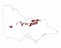 |
Higher level alluvial fans and aprons occur predominantly on the south side of the Wimmera River, adjoining the consolidated material of the Western uplands (2.1, 2.2, 2.3) from which they were derived. The alluvial fans and aprons extend from south of Horsham to the Douglas Depression in the west and Dadswells Bridge in the east. The alluvial systems extend south into the Glenelg Hopkins CMA region but finish less than 10 km over the catchment divide. Depth of apron material over the underlying older material (consolidated or not) may vary and may be quite shallow with Neogene ferruginised sediments close to the surface in the Brimpaen area and Grampians sandstone north-west of the western Black Range. Apron and alluvial plain sediments belong to the Shepparton Formation where once extensive fluvial systems extended across much of the Murray Basin. These unconsolidated sediments conformably overlie the Neogene Parilla Sand. The lithology of this formation is largely a mix of gravels, sands and silts that through groundwater fluctuations combined with pedogenesis have altered the nature of these sediments.
The major streams which flow north across the plains between the Grampians and Horsham are Norton Creek, the Mackenzie River, its tributary Bungalally Creek, and Burnt Creek. All are tributaries of the Wimmera River. Burnt Creek flows across the Drung floodplain before entering the Wimmera River near Horsham. All these streams are relatively inactive. This feature together with the even shallow slope, a drop of over 30 metres down from south to north over a distance of at least 20 km, suggests a stagnant alluvial plain landform pattern superimposed on an apron of material derived in part at least from the Grampians. Several different map units surround the near isolated plain. These include the Grampians Ranges to the south and south-east, the St Helens gentle plains and Drung alluvial plains soil-landform units to the north and the relatively elevated Darragan rolling rises unit to the north-west. An area of isolated and clustered lake and lunettes, now mapped as the Kingcourt and Pine Lake soil-landform units respectively, occupy areas to the south west.
The variety of soils which occur on the plain include grey Vertosols, brown Sodosols and Yellow and brown Kandosols. Sand sheets (Barrabool map unit) are also present. Within the plain there may be a possible subdivision based on the proportions of Vertosols relative to Sodosols and Kandosols (i.e. the Yallambee with the greater area of Vertosols than the Glencoe map units). Some soil properties may well be limiting factors to primary production. For cereal production these include the coarse blocky structure and the very strong ie very hard, consistence of both surface soils and subsoils of some Vertosols and the strong consistence of the surface soils of some Kandosols.
Remnant vegetation communities on the flat plains and sandy clay plains are dominated by woodlands including Plains Woodland, Shallow Sands Woodland, Damp Sands Herb-rich Woodland, Heathy Woodland, Creekline Sedgy Woodland, Dry Creekline Woodland, Sand Ridge Woodland, Shrubby Woodland, Riparian Woodland, Red Gum Wetland and Plains Grassy Woodland.
Related information on VRO
- Land Inventory of the Loddon River Catchment - a reconnaissance survey (N Schoknecht 1988)
- A Study of the Land in the Catchment of the Avoca River (M. S. Lorimer and J. N. Rowan 1982)
- A Study of the Land in the Catchment of the Broken River (Allen S. Rundle and R. K. Rowe 1974)
- A Study of the Land in the Grampians Area (Sibley 1967)
- Land Inventory of the Wimmera Systems and Rocklands Water Supply Catchments - A Reconnaissance Survey (L.A. White, P. J. Kelynack, F. Gigliotti, P. D. Cook 1985)
© State of Victoria (Agriculture Victoria) 1996 - .

This work, Victorian Resources Online, is licensed under a Creative Commons Attribution 4.0 licence. You are free to re-use the work under that licence, on the condition that you credit the State of Victoria (Agriculture Victoria) as author, indicate if changes were made and comply with the other licence terms.
The licence does not apply to ‘branding’ or some ‘images or photographs’ that may be owned by third parties. We ask you to seek prior approval to use images using the VRO feedback form. Access to higher quality images can also be provided on request.
This page was last updated on .