
A Study of the Land in the Catchment of the Avoca River
This report: A Study of the Land in the Catchment of the Avoca River. was prepared by M. S. Lorimer and J. N. Rowan of the former Soil Conservation Authority and was published in 1982. The survey is one of a series of multi-purpose surveys begun in 1952, designed to provide a broad-scale coverage of the State of Victoria. The purpose was to map, describe and evaluate the biophysical nature of the land to be used as basic information for planning conservation of the land under a variety of uses, and determining its most suitable use in the public interest. The information provides a basis for planning at the State or regional level, and also a systematic background for local investigations such as land capability assessment for specific uses.
To view the information PDF requires the use of a PDF reader. This can be installed for free from the Adobe website (external link).
| Amphitheatre Land System (PDF | Avoca Land System (PDF 495KB) | Bald Hill Land System (PDF 532KB) | Bealiba Range Land System (PDF 802KB) |
| Berrimal Land System (PDF 419KB) | Buckrabanyule Land System (PDF 270KB) | Carapooee Land System (PDF 333KB) | Dalyenong Land System (PDF 780KB) |
| Dooboobetic Land System (PDF 388KB) | Dunluce Land System (PDF 415KB) | Glenlogie Land System (PDF 375KB) | Glenmona Land System (PDF 555KB) |
| Gowar Land System (PDF 524KB) | Ingleburn Land System (PDF 637KB) | Logan Land System (PDF 335KB) | Natte Yallock Land System (PDF 1.5MB) |
| Percydale Land System (PDF 444KB) | Pyrenees North Land System (PDF 848KB) | Pyrenees South Land System (PDF 600KB) | Rathscar Land System (PDF 476KB) |
| Spring Hill Land System (PDF 474KB) | Sugarloaf Land System (PDF 425KB) | Wareek Land System (PDF 666KB) | Wehla Land System (PDF 837KB) |
| Woosang Land System (PDF 269KB) | Yalong Land System (PDF 677KB) | Yeungroon Land System (PDF 544KB) | Yowang Land System (PDF 528KB) |
 | Front page and Table of Contents (PDF 90KB) | |
| Foreword (PDF 82KB) | ||
| Summary (PDF 109KB) | ||
| Acknowledgements (PDF 652KB) | ||
1. | Introduction (PDF 125KB) | |
2. | Climate (PDF 248KB) | |
3. | Geology and Geomorphology (PDF 187KB) | |
4. | Soils (PDF 231KB) | |
5. | Native Vegetation (PDF 1.2MB) | |
6. | Land Use (PDF 673KB) | |
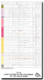
7. | Land Systems (PDF 206KB) (For Individual Land Systems refer to list above) | |
8. | Soil Conservation (PDF 935KB) | |
| References (PDF 144KB) | ||
| Appendix I - Chemical Data for Soil Profiles (PDF 352KB) | ||
| Appendix II - Physical Data for Soil Profiles (PDF 130KB) | ||
| Appendix III - Methods of Soil Analysis (PDF 94KB) | ||
| Appendix IV - Soil Profile Descriptions (PDF 663KB) | ||
| Appendix V - Atterberg Limits (PDF 105KB) | ||
| Appendix VI - Methods of Land System Description (PDF 149KB) | ||
| Apendix VII - Floristic List (PDF 136KB) |
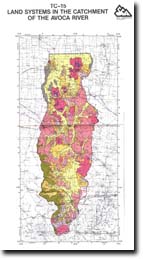 A Study of the Land in the Catchment of the Avoca River - Map (PDF 1.5MB) |
© State of Victoria (Agriculture Victoria) 1996 - .

This work, Victorian Resources Online, is licensed under a Creative Commons Attribution 4.0 licence. You are free to re-use the work under that licence, on the condition that you credit the State of Victoria (Agriculture Victoria) as author, indicate if changes were made and comply with the other licence terms.
The licence does not apply to ‘branding’ or some ‘images or photographs’ that may be owned by third parties. We ask you to seek prior approval to use images using the VRO feedback form. Access to higher quality images can also be provided on request.
This page was last updated on .