Deverall Hill
|
This information has been obtained from the report: Eruption Points of the Newer Volcanic Province of Victoria by Neville Rosengren. This report was published in 1994 and was prepared for the National Trust of Australia (Victoria) and the Geological Society of Australia (Victorian Division). The review of eruption points was based on an earlier unpublished manuscript Catalogue of the post-Miocene volcanoes of Victoria compiled by O P Singleton and E B Joyce (Geology Department, University of Melbourne 1970). |
| 37 31 44S 144 38 15E (external link); 7822-4-1 (Sunbury) 912435. 6 km SE of Gisborne. |  Deverall Hill | |
Calder Highway, Bulla. | ||
Private land. | Grazing, small disused quarry, outcrop. | |
Type 9: | Composite lava and scoria volcano. | |
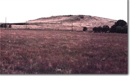
Deverall Hill is a steep volcanic hill with a circular depression at the summit surrounded by outward-facing lava ridges. On the western slopes are twin lava ridges marking either the edges of a flow or radial squeeze-ups similar to Mount Kororoit. The topography has been described as resulting from erosion of a scoria cone exposing the central plug and lava flows. | ||
490+m; 30 m. | ||
Regional: | This is an excellent example of the eroded volcanoes of the Gisborne-Sunbury area and forms part of a unique (Victorian context) group of similar, closely spaced lava volcanoes that are the only hills in this landscape. | |
References: | Edwards, A.B. & Crawford, W. 1940. The Cainozoic volcanic rocks of the Gisborne district, Victoria. Proceedings of the Royal Society of Victoria 52, pp. 281-311. | |
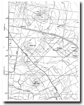
 Deverall Hill 7822-4-1 (Sunbury) | ||


