
Mount Kororoit
|
This information has been obtained from the report: Eruption Points of the Newer Volcanic Province of Victoria by Neville Rosengren. This report was published in 1994 and was prepared for the National Trust of Australia (Victoria) and the Geological Society of Australia (Victorian Division). The review of eruption points was based on an earlier unpublished manuscript Catalogue of the post-Miocene volcanoes of Victoria compiled by O P Singleton and E B Joyce (Geology Department, University of Melbourne 1970). |
| 37 39 16S 144 39 41E (external link); 7822-4-2; (Sydenham West); 936296. | 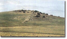 Mount Kororoit | |
5 km SW of Diggers Rest. Leakes Road. | ||
Melton. | ||
Private land. | Cropping on lower slopes, grazing, abundant outcrop at summit. | |
Type 9: | Composite lava and scoria volcano. | |
Mount Kororoit is a small asymmetric conical hill with a flattened summit, steep southern slopes and a long, gentle northern slope of eroded lava. On this flow is a broad, swampy depression north of Holdens Road. The hill is predominantly of scoria and is capped by a rocky outcrop of lava and lava agglomerate. Several narrow arcuate ridges of vesicular lava are prominent on the summit and the northern slopes and suggest a complex internal structure of the volcano. | ||
237 m; 60 m. | ||
State: | This is a fine example of the small, complex eruption points that occur on the plains between Melbourne and Woodend. It is an unusual scoria cone in the context of the Newer Volcanics Province in that late-stage lava flows erupted from and filled the throat and crater of the volcano, covering earlier formed scoria deposits. Geophysical studies of Mount Kororoit have been the basis for developing a model for the evolution of these type of volcanoes. | |
References: | Coulson, A. (1938). The basalts of the Geelong district. Proceedings of the Royal Society of Victoria 50, pp. 394-402. Edwards, A.B. & Crawford, W. (1940). The Cainozoic volcanic rocks of the Gisborne district, Victoria. Proceedings of the Royal Society of Victoria 52, pp. 281-311. Ollier, C.D. & Joyce, E.B. (1964). Volcanic physiography of the Western Plains of Victoria. Proceedings of the Royal Society of Victoria 77, pp. 357-376. Ollier, C.D. (1967a). Landforms of the Newer Volcanic Province of Victoria. In J.N. Jennings & J.A. Mabbutt (eds), Landform studies from Australia and New Guinea. ANY Press. pp. 315-339. Fischer,W.S. & Thomas, L. (1981). A study of Mount Kororoit, Victoria - a small volcanic vent. Proceedings of the Royal Society of Victoria 93, pp. 99-103. | |
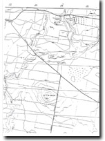 Mount Kororoit 7822-4-2 (Sydenham West) | |

© State of Victoria (Agriculture Victoria) 1996 - 2025.

This work, Victorian Resources Online, is licensed under a Creative Commons Attribution 4.0 licence. You are free to re-use the work under that licence, on the condition that you credit the State of Victoria (Agriculture Victoria) as author, indicate if changes were made and comply with the other licence terms.
The licence does not apply to ‘branding’ or some ‘images or photographs’ that may be owned by third parties. We ask you to seek prior approval to use images using the VRO feedback form. Access to higher quality images can also be provided on request.
This page was last updated on 23/11/2018.