
Bittern Sand
Symbol: Bis
Geology - Tertiary period sediments.
Landform - Gently undulating rises. The original late Tertiary land surface is now weakly dissected and the present landscape consists of gently undulating rises to gently undulating plains with slopes generally less than 3 %.
Soils
These soils are similar to Toomuc sandy loam, but are arbitrarily separated from them on the basis of their landscape position. Toomuc sandy loam occurs lower in the landscape and is generally associated with low to very low dunes with Cranbourne sand.
The surface soils of Bittern sand are grey or dark grey loamy sands or sandy loams about 250 mm deep, overlying a bleached layer of similar texture. Nodules of iron oxide are common at the bottom of this layer. Mottled light grey and yellowish brown medium clays or sandy clays occur from about 700 mm and continue to at least 1500 mm depth. Red mottling generally occurs in the deep subsoil.
Typical profile of Bittern Sand
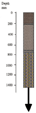 | 0 - 250 mm. Grey or dark brownish grey sandy loam to loamy sand. Clear transition to: 250 - 700 mm. Pale grey to pale brownish grey sandy loam to loamy sand. Concretions of ironstone gravel are common at the bottom of this layer. Sharp transition to: 700 mm - 1.4 m. Mottled light grey, yellowish brown and red light or medium clay generally becoming medium to sandy clay by about 1 m. |
These soils are mainly used for pasture for beef and dairy cattle. Because the surface soil is sandier and deeper than Bittern sandy loam, they are often cultivated for horticulture, mainly vegetables. However, the "spewy" nature of the bleached zone tends to make makes cultivation difficult when the soil is wet. Sub-surface drainage is required if vegetables are to be grown throughout the year.
Bittern sandy loam and Bittern sand
Symbol: Bi:Bis
This mapping unit describes areas which comprise both Bittern sandy loam and Bittern sand. The proportion of each soil ranges between 30 and 70% of the total area.
Bittern sandy loam with Bittern sand
Symbol: Bi/Bis
This mapping unit describes areas which comprise mostly Bittern sandy loam with some Bittern sand. The percentage of the dominant soil, Bittern sandy loam, is at least 70% of the total area.
Bittern sand and Cranbourne sand
Symbol: Bis:Cr
This mapping unit describes areas which comprise both Bittern sand and Cranbourne sand (see later). The proportion of each soil ranges between 30 and 70% of the total area.
Bittern sand with Cranbourne sand
Symbol: Bis/Cr
This mapping unit describes areas which comprise Bittern sand with some Cranbourne sand. The percentage of the dominant soil (ie. Bittern sand) is at least 70% of the total area.

© State of Victoria (Agriculture Victoria) 1996 - 2025.

This work, Victorian Resources Online, is licensed under a Creative Commons Attribution 4.0 licence. You are free to re-use the work under that licence, on the condition that you credit the State of Victoria (Agriculture Victoria) as author, indicate if changes were made and comply with the other licence terms.
The licence does not apply to ‘branding’ or some ‘images or photographs’ that may be owned by third parties. We ask you to seek prior approval to use images using the VRO feedback form. Access to higher quality images can also be provided on request.
This page was last updated on 23/11/2018.