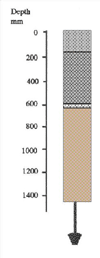
Toomuc sandy loam
Symbol: To
Geology - Recent to Pleistocene alluvial and aeolian sediments
Landform - Gently undulating sand plain
Soils- This soil type was first described by Holmes et al. (1940). The surface soils are grey or dark grey sands to sandy loams about 250 mm deep, overlying a bleached layer of similar texture. Nodules of iron oxide are common at the bottom of this layer. Mottled light grey, yellow-grey and yellow-brown light to medium clays occur from about 600 mm and continue to at least 1500 mm. Red-brown mottling and heavy clay textures generally occur in the deep subsoil. Soil Pit Site GP 21 is an example of a Toomuc sandy loam profile.
Typical profile of Toomuc sandy loam
 | 0 - 250 mm. Grey or dark grey sandy loam to loamy sand. Clear transition to: 250 - 600 mm approx. Pale grey sandy loam or sand. Concretions of ironstone gravel are common at the bottom of this layer. Sharp transition to: 600 mm - 1.4 m. Mottled light grey, yellow-grey and yellow-brown light or medium clay generally becoming medium to heavy clay by about 1 m. |
These soils are mainly used for pasture for beef and dairy cattle. Although they may be cultivated for vegetable crops, the "spewy" nature of the bleached zone makes cultivation difficult when the soil is wet. Sub-surface drainage is required if vegetables are to be grown throughout the year. These soils are regarded as second class for vegetable production when compared to Cranbourne sand.
Toomuc sandy loam with Cranbourne sand
Symbol: To/Cr
This mapping unit describes areas comprising mostly Toomuc sandy loam with some Cranbourne sand. The percentage of the dominant soil (ie. Toomuc sandy loam) is at least 70% of the total area.
Toomuc sandy loam and Narre clay loam
Symbol: To:Nr
This mapping unit describes areas which comprise both Toomuc sandy loam and Narre clay loam. The proportion of each soil ranges between 30 and 70% of the total
Toomuc sandy loam with Narre clay loam
Symbol: To/Nr
This mapping unit describes areas which comprise mostly Toomuc sandy loam with some Narre clay loam. The percentage of the dominant soil, Toomuc sandy loam, is at least 70% of the total area.


