Rosebud
Rosebud - Symbol: Ro
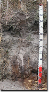
| The Rosebud mapping unit occurs south of Rosebud, mostly between Boneo and Cape Schanck roads, Browns and Baldrys roads and Main Creek. It is formed on early Pleistocene sands that occur as dune fields on the western slopes of Selwyn’s Fault. Much of the area remains as undisturbed damp sands herb-rich woodland with some heathy woodland under the management of National Parks and is known as “Greens Bush”. The surface soils are typically dark grey sands becoming lighter in colour by about 300 mm depth. Dark brown and yellow brown weakly cemented sand usually occurs at about 900 mm. Mottled light yellowish brown and light grey sands occur under the cemented zone, but the colours of the sand are quite variable. These sands generally continue to depth but it is likely that some areas may have clayey sand deep subsoils. The surface soils are typically acidic with a pH around 5.5 to 6.0 and the subsoils around pH 5.5 to 6.5. These soils are described as Aeric Podosols using the Australian Soil Classification. Apart from the National Park, most of the area is under grazing, but there is some vegetable production on the lower slopes near Boneo road. Like the soils on the Boneo mapping unit, these soils have a low inherent fertility and as they are sandy they retain little water. With irrigation, fertilizers and additional organic matter they could become highly productive. As this unit is mostly high in the landscape, irrigation may cause changes in water quality and quantity and change the depth to groundwater in the Boneo area. |  Aeric Podosol near Rosebud |
Rosebud with swamps - Symbol: Ro/sw
This mapping unit describes a small area within which geologists have mapped some swampy areas. The sandy surface soils in the low areas tend to be darker in colour as they have more organic matter. An impeding layer, probably a cemented sand layer is likely to be present in the deep subsoil. These soils are described as Semiaquic Podosols using the Australian Soil Classification.


