
Red Hill
Red Hill - Symbol: Rh
| The “red” soils near Red Hill are included in this mapping unit. Small areas of soils, which are duller in colour and would be otherwise classified within the Flinders mapping unit, occur in areas of restricted drainage but it proved impractical to make any separation. All of the soils are developed on Tertiary basalts. The landform is rolling low hills and the remnant vegetation is herb rich foothill forest with damp forest in the incised depression lines. Approximately half the soils are classified krasnozems under an earlier soil classification, but are now referred to as Red Ferrosols using the Australian Soil Classification System - reflecting the fact that they have high a free iron oxide content. These Red Ferrosols are deep, friable, red and porous soils. About half of the remainder of the soils have either dark greyish brown to dark brown light clay to clay loam surface soilsoverlying reddish brown to strong brown medium to heavy clay subsoils. The other half are much greyer, with dark brownish grey light clay to clay loam surface soils overlying yellowish brown medium to heavy clay subsoils. As mentioned in the previous paragraph, these soils would be classified under Flinders if they could have been delineated on the map. | 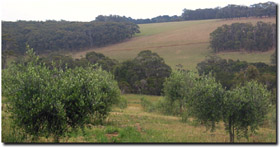 Rolling hills with Ferrosols near Main Ridge. |
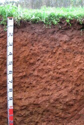 Red Ferrosol at Red Hill South | The typical surface soil is a dark reddish brown light clay or clay loam with a strong fine crumb structure, grading at about 200 mm depth, into a strong brown or dark reddish brown light or medium clay with some small ironstone concretions. From about 600 mm, mottled reddish brown and yellow brown medium clays occur, and these continue until decomposing basalt is encountered, generally deeper than 1.8 metres. Odd floaters (small pieces of basalt) and large ironstone concretions may be scattered in the soil profile. The clay content of these soils is higher than that indicated by their field texture, with the subsoils being mainly clay with about 10 to 15% iron oxide. Some of the “non-Red Ferrosol” soils, particularly the greyest, often have a bleached subsurface soil with slight amounts of small ironstone concretions. These exhibit an abrupt change at about 300 mm between the clay loam surface soil and the medium to heavy clay subsoil. The deep subsoils are all dominantly brown with an increasing red-brown mottle. Decomposing basalt is generally, but not always, deeper than 1.8 metres depth. The soils within this mapping unit are highly prized for berry crops and orchards, particularly apples. Where slopes are favourable, more land is being planted with vines. After the vines are well established on these soil no further supplementary water is needed and plant vigour needs to be controlled. |

© State of Victoria (Agriculture Victoria) 1996 - 2025.

This work, Victorian Resources Online, is licensed under a Creative Commons Attribution 4.0 licence. You are free to re-use the work under that licence, on the condition that you credit the State of Victoria (Agriculture Victoria) as author, indicate if changes were made and comply with the other licence terms.
The licence does not apply to ‘branding’ or some ‘images or photographs’ that may be owned by third parties. We ask you to seek prior approval to use images using the VRO feedback form. Access to higher quality images can also be provided on request.
This page was last updated on 23/11/2018.