
French Island, Phillip Island and Bass Coast - Soils and Landforms
This map is designed to be viewed on-screen. The map legend can be clicked on to provide information about each of the map units. 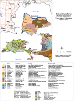 French Island, Phillip & Bass Coast | A PDF map is provided here that is suitable for printing at A3 or A4 scale. Note that this is not a clickable map when opened. To view the information PDF requires the use of a PDF reader. This can be installed for free from the Adobe website (external link).  French Island, Phillip Island & Bass Coast |

© State of Victoria (Agriculture Victoria) 1996 - 2025.

This work, Victorian Resources Online, is licensed under a Creative Commons Attribution 4.0 licence. You are free to re-use the work under that licence, on the condition that you credit the State of Victoria (Agriculture Victoria) as author, indicate if changes were made and comply with the other licence terms.
The licence does not apply to ‘branding’ or some ‘images or photographs’ that may be owned by third parties. We ask you to seek prior approval to use images using the VRO feedback form. Access to higher quality images can also be provided on request.
This page was last updated on 23/11/2018.