
Bittern
Bittern - Symbol Bi
This mapping unit is quite extensive in the northern and western part of the Shire. The sediments on which this unit occur are generally unconsolidated or weakly cemented clays or sandy clays deposited during the Tertiary period and mostly overlie Palaeozoic sediments. Around Somers and Balnarring they overlie the Tertiary basalts. The late Tertiary surface resulting from this deposition is now dissected and the landscape is undulating low hills with both shallow and deeply incised depression lines. Frequently these depression lines expose the underlying older rocks and sediments. Where the depth of the Tertiary sediments is shallow there is some uncertainty in soil classification. The mapping units Bittern with Flinders (Bi/Fl) and Langwarrin with Bittern (Lw/Bi) are mapping units where areas of basaltic soil (Bi/Fl) or soils on older sediments (Lw/Bi) occur at the surface. | 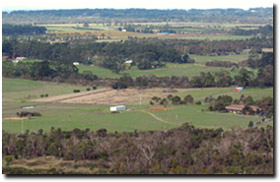 Overlooking Moorooduc Plains from Mount Eliza |
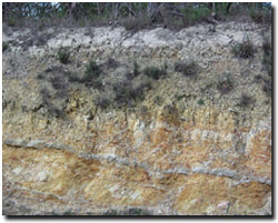 Typical soil profile developed on Tertiary Baxter Sandstone in the Bittern mapping unit. | Originally the soils supported a lowland forest. Eucalypt species included messmate, narrow-leaf peppermint, with some manna gum, snow gum and silver-leaf stringy bark. Heath, silver banksia and prickly tea tree were common shrubs. Most of the area is now cleared and supports improved pastures. Most of the surface soils are dark greyish brown fine sandy loams to fine sandy clay loams overlying a bleached similarly textured zone, generally containing iron oxide concretions. Yellowish brown often mottled with light brownish grey medium clay appears abruptly below the bleached horizon, generally around 350 mm. Clays or sandy clays continue to at least 1.8 metres depth. Where the subsoil clay is exposed for long periods, for example on farm dam banks and roadside cuttings, it takes on a bright yellowish brown appearance. These soils are best described as Brown or Yellow Chromosols using the Australian Soil Classification. Soil Pit Site MOP1 is an example of a Brown Chromosol near Baxter. Merricks and Merricks, clay are mapping units that occur in drainage lines and open depressions throughout the Mornington Peninsula and may also occur as minor components within the Bittern mapping unit. Site MOP2 is an example of an Aquic Vertosol near Baxter and occurs within an area mapped as Merricks, clay. |
Near Hastings, the soils were highly regarded for apple growing, but many of the orchards are now being abandoned and used as rural residential blocks. Where slopes are favourable, viticulture is fast becoming a popular enterprise. The main constraints to viticulture are shallow surface soils, potential for subsoil waterlogging during wetter periods and, in some cases, a sodic clay subsoil, which impedes root development and water penetration. The sodic soils appear to be more common north of the Bittern-Dromana road and west of Stumpy Gully road. There may be two contributing factors at work here – i). proximity to Port Phillip Bay, which influences the salt content in the rain from the west, and ii). slightly lower rainfall, allowing more sodium to accumulate in the subsoil. These soils are most likely to be classified as Sodosols using the Australian Soil Classification.
Bittern, sand surface - Symbol: Bi,s
Only isolated occurrences of this mapping unit exist and much is now cleared of native vegetation. The soils are similar to that described above but the surface soil and the bleached subsoil are deeper and are mostly sand. The deep subsoil is also sandier, a clayey sand or sandy clay, and may be cemented. If water is available, vegetables may be grown on this unit.
Bittern, sandy loam surface - Symbol: Bi,sl
The soils on this mapping unit are similar to those on the Bittern mapping unit except the surface soils are sandier, being sandy loams to loamy sands. The clay subsoils occurs deeper, at about 400 to 500 mm depth.
Bittern: Bittern sandy loam - Symbol: Bi:Bi,sl
This mapping unit delineated areas where between 35 and 65 percent of the soils may be classified within the Bittern mapping unit or the Bittern sandy loam unit. That is the surface soils within the area range from fine sandy clay loams to sandy loams, and occasionally loamy sands. All soils are texture contrast soils with a light to medium clay subsoil from about 400 to 500 mm depth.
Bittern with Flinders - Symbol: Bi/Fl
As mentioned under Geology, the late Tertiary sediments mantle earlier rocks and sediments, and where the Tertiary sediments are shallow; it is often difficult to make decisions on the geology on which the soils have developed. In the case of this mapping unit, the Tertiary sediments partially overlie the mid-Tertiary basalts, with about 10 to 35% of the area being covered by soils on Tertiary sediments.
On both the Tertiary sediments and the Tertiary basalts texture contrast soils have developed, with a fine sandy clay loam or clay loam surface abruptly overlying a medium to heavy clay subsoil at about 300 to 400 mm. The soils on the Tertiary sediments (Bittern) tend to have sandier surface soils and have brighter coloured clay subsoils than those on the Tertiary basalts (Flinders). Both soils generally contain ferruginous nodules (i.e. ‘buckshot’) above the clayey subsoil. In some instances the basalts occur higher in the landscape, for example just west of Balnarring, and in other cases the decomposing basalt appears to be exposed near drainage lines, for example near Hanns Creek reserve.
Most of the land within this mapping unit is used for grazing and rural residential blocks. Where slopes are favourable, viticulture may be an option. The main constraints to viticulture are shallow surface soils and the potential for subsoil waterlogging during wetter periods, particularly on flatter sites. The remnant vegetation is described as lowland forest.

© State of Victoria (Agriculture Victoria) 1996 - 2025.

This work, Victorian Resources Online, is licensed under a Creative Commons Attribution 4.0 licence. You are free to re-use the work under that licence, on the condition that you credit the State of Victoria (Agriculture Victoria) as author, indicate if changes were made and comply with the other licence terms.
The licence does not apply to ‘branding’ or some ‘images or photographs’ that may be owned by third parties. We ask you to seek prior approval to use images using the VRO feedback form. Access to higher quality images can also be provided on request.
This page was last updated on 23/11/2018.