
Land Degradation
See also Statewide Land Degradation
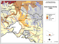
The tunnel and gully erosion maps shown here are subsets from the original data presented in the articles on tunnel erosion and gully erosion in the Statewide VRO website, so that the accuracy of information has not been improved. Tunnel erosion has been found in clusters, especially around Sunbury and in the area between Romsey and Lilydale. Others sites were observed near the Bunyip River and in the south-eastern part of the region. Some of these tunnels may have been destroyed whilst new tunnels may have formed elsewhere and are not marked.
| Similarly, the spatial distribution of gully erosion in the region may have altered since the time that the map was constructed. The highest density of gullying recorded was 0.2 - 0.5 km/km2 around Sunbury and it extended to the north-east near Kilmore. A large area of gully density < 0.2 km/km2 was mapped to the north-east, east and south-east of Melboune. Most tunnel erosion occurred in gullied areas with these two density classes. Gully density was rated as 'low' in most of the region. |


© State of Victoria (Agriculture Victoria) 1996 - 2025.

This work, Victorian Resources Online, is licensed under a Creative Commons Attribution 4.0 licence. You are free to re-use the work under that licence, on the condition that you credit the State of Victoria (Agriculture Victoria) as author, indicate if changes were made and comply with the other licence terms.
The licence does not apply to ‘branding’ or some ‘images or photographs’ that may be owned by third parties. We ask you to seek prior approval to use images using the VRO feedback form. Access to higher quality images can also be provided on request.
This page was last updated on 23/11/2018.