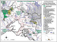
Declared Water Supply Catchments
See also Declared Water Supply Catchments in Victoria
Formally known as Proclaimed Water Supply Catchments, DWSCs are the basis for catchment planning and management under the provisions of the Catchment and Land Protection Act, 1994. (formerly the Soil Conservation and Land Utilization Act, 1958).
Under this Act, Declared Special Areas (Water Supply Catchments) officially recognise designated catchments for water supply purposes. This process highlights to the community, land managers and planners, the importance of the catchment for water supply purposes.
Declaration is now initiated by the Catchment Management Authority's (CMA) recommendation to the relevant State Government Minister. Following Ministerial approval, notification is made in the Government Gazette.The Land Conservation Council (LCC) previously had jurisdiction over these proclamations. For some of these DWSCs in the region, the LCC was charged with approving any proposed Determination of Land Use (now known as a Special Area Plan) put forward by the Soil Conservation Authority (SCA). The Determination of Land Use generally established permissible land and water uses within the defined area and stipulated planning controls and potential hazards to the proclaimed water supply.
| The Declared Water Supply Catchments map shows those catchment areas as proclaimed under the Soil Conservation and Land Utilization Act, 1958 in conjunction with the Land Conservation Act, 1970, and subsequently incorporated into the Catchment and Land Protection Act, 1994. This layer identifies domestic Water Supply Catchments that are subject to a Land Use Determination or a Land Use Notice. Data was derived from the proclaimed water supply catchment (L100) layer in the Department of Sustainability and Environment Corporate Geospatial Data Library. Mapping was undertaken by the Centre for Land Protection Research. |
DWSCs located throughout the Port Phillip region include:
PWSC No. | Catchment Name |
3 | Parwan |
8 | Riddells Creek (Main Creek) |
9 | Gisborne-Sunbury (Barringo) |
10 | Lancefield (Deep Creek) |
11 | Romsey (Upper Bollinda Creek) |
13 | Mount Macedon (Stony Creek) |
14 | Macedon (Bawden, Stony Creek & Kitty English Reservoir) |
17 | Sunbury (Bollinda, Cherlies & Main Creeks) |
18 | Djerriwarrh |
21 | Bunyip River |
24 | Healesville |
28 | Lake Merrimu |
29 | McCraes Creek |
31 | Drouin |
32 | Tarago River |
34 | Lake Merrimu (Goodmans Creek) |
37 | Rosslynne Reservoir (Jackson Creek) |
39 | Rosslynne Reservoir (Riddells Creek) |
40 | Micks Creek |
44 | Lake Merrimu (Lerderderg River) |
49 | Running Creek (Hurstbridge WWT) |
60 | Monument Creek |
64 | Britannia Creek |
84 | Tomahawk Creek (Gembrook) |
114 | Pykes Creek and Werribee Reservoirs |


