
Vertosols
Vertosols are clay soils that display shrinking and swelling during wetting and drying cycles. They exhibit strong cracking when dry and at depth have slickensides and/or lenticular peds.
Note that other soil types may also occur within these mapped areas either dominantly or sub-dominantly depending on factors such as climate, landform, geology, vegetation and degree of weathering. This map will continue to be updated as new information becomes available. Access the Soil and Land Survey Directory from this website to find out about more detailed information from various soil and land surveys that cover parts of this region. |
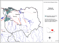
Grey and Black Vertosols have been found in many parts of the North East region, but are not extensive and usually occur in low-lying situations. In many cases their distribution is so isolated that they cannot be shown in the map above. They are most common on the riverine plains in the north west part of the region. Where they are shown to occur on the map, they are mostly only a minor occurrence in association with other soil types.
Previously referred to as:
light clay texture, clear to abrupt boundary change. light to medium clay, slickensides present, becoming increasingly alkaline and sodic with depth. |
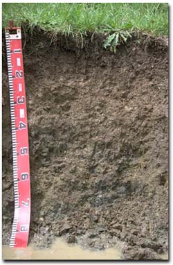 Grey Vertosol in the Tallangatta valley. |
References
Rowe, R.K (1967). A Study of the Land in the Victorian Catchment of Lake Hume. Soil Conservation Authority. Victoria. Technical Communication 5.
Rowe, R.K (1972). A Study of the Land in the Catchment of the Kiewa River. Soil Conservation Authority. Victoria. Technical Communication 8.
Rowe, R.K (1984). A Study of the Land in the Catchments of the Upper Ovens and King Rivers. Soil Conservation Authority. Victoria. Technical Communication 16.
© State of Victoria (Agriculture Victoria) 1996 - 2025.

This work, Victorian Resources Online, is licensed under a Creative Commons Attribution 4.0 licence. You are free to re-use the work under that licence, on the condition that you credit the State of Victoria (Agriculture Victoria) as author, indicate if changes were made and comply with the other licence terms.
The licence does not apply to ‘branding’ or some ‘images or photographs’ that may be owned by third parties. We ask you to seek prior approval to use images using the VRO feedback form. Access to higher quality images can also be provided on request.
This page was last updated on 25/01/2019.