
Kurosols
Kurosols have a strong texture contrast between loamy surface (A) horizons and the clayey subsurface (B) horizon. The subsoils are strongly acid (i.e. pH 5.4 or less). Kurosols can be separated on the basis upper 20 cm subsoil color, into Red, Brown, Yellow, Grey and Black groups.
Note that other soil types may also occur within these mapped areas (either dominantly or sub-dominantly) depending on factors such as climate, landform, geology, vegetation and degree of weathering. This map will continue to be updated as new information becomes available. Access the Soil and Land Survey Directory from this website to find out about more detailed information from various soil and land surveys that cover parts of this region. | |
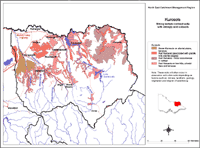
Red Kurosols are the most widespread soils of the lower valley slopes, fans, higher terraces and residual hills in the higher rainfall areas throughout the North East region. Some Brown Kurosols occur on the plains in the northwest of the region. This map will be updated as new information becomes available.
Red Kurosols have previously been referred to as red podzolic soils and red Duplex soils with acid subsoils.
Generalised Description of Red Kurosols Surface (A) horizons: loam or sandy loam texture, 15-20 cm thick, shallow hardsetting A1 overlying bleached A2 horizon, clear to abrupt boundary change. Subsoil (B2) horizon: clay texture, well developed fine sub-angular blocky peds, strongly acid. |
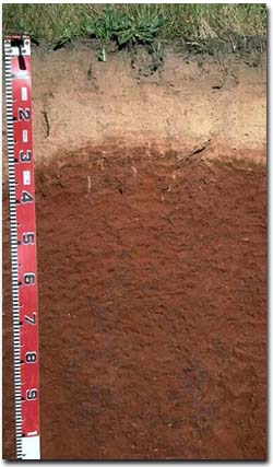 Red Kurosol on granite near Springhurst. |
References
Rowe, R.K (1967). A Study of the Land in the Victorian Catchment of Lake Hume. Soil Conservation
Authority. Victoria. Technical Communication 5.
Rowe, R.K (1972). A Study of the Land in the Catchment of the Kiewa River. Soil Conservation Authority.
Victoria. Technical Communication 8.
Rowe, R.K (1984). A Study of the Land in the Catchments of the Upper Ovens and King Rivers. Soil
Conservation Authority. Victoria. Technical Communication 16.
© State of Victoria (Agriculture Victoria) 1996 - 2025.

This work, Victorian Resources Online, is licensed under a Creative Commons Attribution 4.0 licence. You are free to re-use the work under that licence, on the condition that you credit the State of Victoria (Agriculture Victoria) as author, indicate if changes were made and comply with the other licence terms.
The licence does not apply to ‘branding’ or some ‘images or photographs’ that may be owned by third parties. We ask you to seek prior approval to use images using the VRO feedback form. Access to higher quality images can also be provided on request.
This page was last updated on 25/01/2019.