
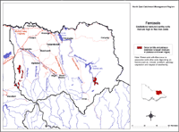
Ferrosols
| Ferrosols are soils lacking strong texture contrast between surface (A) horizons and the upper subsoil (B21) horizon. These soils are also characterised by relatively high levels of free iron oxide i.e. free iron oxide content greater than 5%. Several Sub-orders can be separated, based on the colour of the major part of the subsoil e.g. into Red, Brown and Yellow groups. Only Red Ferrosols have been described in North East Victoria. Ferrosols are usually formed on deeply weathered basaltic parent materials and therefore have only a limited distribution in the North East region. They occur mainly on hilly country to the west of the King River, where they are limited to basalt residuals on broad plateaus and broad ridges. In the east of the region, they are restricted to the Deep Creek basalt. | 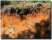 Ferrosol near Whitfield. |
Note that other soil types may also occur within these mapped areas (either dominantly or sub-dominantly) depending on factors such as climate, landform, geology, vegetation and degree of weathering. This map will continue to be updated as new information becomes available. Access the Soil and Land Survey Directory from this website to find out about more detailed information from various soil and land surveys that cover parts of this region. |
These soils typically have well-structured surface (A1) horizons darkened with organic matter and a very well structured subsoil (B) horizon which is friable when moist. Ferrosols are generally strongly acid throughout. Generally the pH ranges from 4.5 to 5.6 in the surface horizon and 4.4 to 5.2 in the subsoil. They also have quite a high (greater than 45%) clay content throughout the deep profile. However, in some cases the profile can have high levels of fine sand and silt throughout, suggesting that wind-blown materials have been incorporated into the soil development.
Ferrosols have previously been referred to as chocolate soils (Rowe 1967) or red Gradational soils on basalt (Rowe 1984).
Reference
Rowe, R.K (1967). A Study of the Land in the Victorian Catchment of Lake Hume. Soil Conservation Authority. Victoria. Technical Communication 5.
Rowe, R.K (1984). A Study of the Land in the Catchments of the Upper Ovens and King Rivers. Soil Conservation Authority. Victoria. Technical Communication 16.
Rowe, R.K (1972). A Study of the Land in the Catchment of the Kiewa River. Soil Conservation Authority. Victoria. Technical Communication 8.
© State of Victoria (Agriculture Victoria) 1996 - 2025.

This work, Victorian Resources Online, is licensed under a Creative Commons Attribution 4.0 licence. You are free to re-use the work under that licence, on the condition that you credit the State of Victoria (Agriculture Victoria) as author, indicate if changes were made and comply with the other licence terms.
The licence does not apply to ‘branding’ or some ‘images or photographs’ that may be owned by third parties. We ask you to seek prior approval to use images using the VRO feedback form. Access to higher quality images can also be provided on request.
This page was last updated on 25/01/2019.