
ESAS2
| Plot: Bakers | Location: Rutherglen |
| Aust. Soil Class: Sodic, Eutrophic, Brown DERMOSOL | |
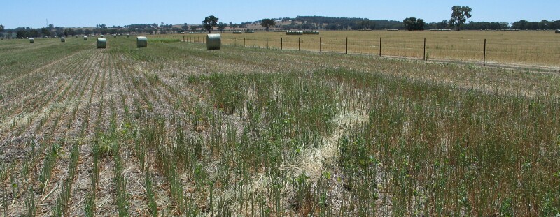 ESAS2 Landscape |
Soil Profile Morphology:
Surface Soil
Ap | 0-5 cm | Brown (10YR4/3); very fine sandy loam; weak to very firm consistence (dry); pH 6.6; abrupt change to: | 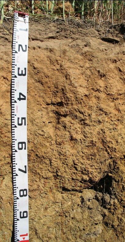 ESAS2 profile |
A12 | 5-10 cm | Brown (7.5YR4/3); very fine sandy loam; firm consistence (dry); pH 6.8; abrupt change to: | |
A2 | 10-50 cm | Brown (7.5YR5/4 moist and 7.5YR4/4 dry); light fine sandy clay loam; firm to very firm consistence (dry); pH 5.7; clear change to: | |
A3 | 15-30 cm | Strong brown (7.5YR5/6); light fine sandy clay loam; weak coarse (20-55 mm) blocky structure; firm to very firm consistence (dry); macropores present; pH 5.3; clear change to: | |
| Subsoil | |||
B1 | 30-40 cm | Strong brown (7.5YR5/8); fine sandy clay loam; weak to moderate coarse to medium (10-50 mm) subangular blocky structure; firm to very firm consistence (dry); macropores present; pH 6.2; clear change to: | |
B21 | 40-55 cm | Strong brown (7.5YR5/6); light clay (fine sandy); weak to moderate coarse to medium (10-50 mm) subangular blocky structure; very firm consistence (dry); macropores present; pH 6.6; clear change to: | |
B22 | 55-90 cm | Strong brown (7.5YR5/6); light clay; moderate to strong coarse to medium (10-50 mm) polyhedral structure; strong consistence (dry); macropores present; pH 7.4; gradual change to: | |
B23 | 90-130 cm | Light reddish brown (2.5YR6/3) with brownish yellow (10YR6/6), yellowish red (5YR4/6) and grey (10YR6/1) mottles; medium clay; moderate to strong coarse (50-100 mm) prismatic, parting to moderate to strong coarse to medium (10-50 mm) and further parting to fine (5-10 mm) subangular blocky structure; strong to very strong consistence (dry); pH 7.1. | |
- Gradual increase in texture (i.e. clay content) between surface (A) horizons and subsoil (B) horizons.
Soil Profile Characteristics:
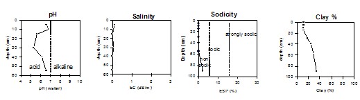
pH | Salinity Rating | Sodicity | Dispersion | |
Surface (A21 horizon) | Slightly Acid | Very Low | Non-Sodic | None |
Subsoil (B1 horizon) | Strongly Acid | Very Low | Non-Sodic | None |
Deeper subsoil (at 90 - 130 cm) | Slightly Alkaline | Very Low | Slightly Sodic | None1 |
Horizon | Horizon Depth (cm) | pH (water) | pH (CaCl2) | EC 1:5 | Exchangeable Cations | ||||
Ca | Mg | K | Na | ||||||
meq/100g | |||||||||
Ap | 0-5 | 6.6 | 6.3 | 0.14 | 5.9 | 0.95 | 0.84 | <0.05 | |
A12 | 5-10 | 6.8 | 6.3 | 0.08 | 5.2 | 0.73 | 0.79 | <0.05 | |
A2 | 10-15 | 5.7 | 5.2 | <0.05 | 3.3 | 0.46 | 0.49 | <0.05 | |
A3 | 15-30 | 5.3 | 4.8 | 0.06 | 2.7 | 0.51 | 0.34 | <0.05 | |
B1 | 30-40 | 6.2 | 5.6 | <0.05 | 4.1 | 0.83 | 0.5 | <0.05 | |
B21 | 40-55 | 6.6 | 6 | <0.05 | 5.1 | 1.2 | 0.63 | <0.05 | |
B22 | 55-90 | 7.4 | 6.7 | 0.06 | 5.7 | 2.6 | 0.51 | 0.21 | |
B23 | 90-130 | 7.1 | 6 | 0.06 | 6 | 5.4 | 0.61 | 0.95 | |
Horizon | Horizon Depth (cm) | Exchangeable Aluminium (mg/kg) | Exchangeable Acidity (meq/100g) | Field Capacity pF 2.5 | Wilting Point pF 4.2 | Coarse Sand (0.2-2.0 mm) | Fine Sand (0.02-0.2 mm) | Silt (0.002-0.02 mm) | Clay (<0.002 mm) |
Ap | 0-5 | 2.5 | 25.9 | 5.2 | 9 | 54 | 20 | 12 | |
A12 | 5-10 | 2.4 | 22.4 | 4.6 | 9 | 53 | 22 | 11 | |
A2 | 10-15 | <10 | 4.5 | 22.9 | 4.5 | 10 | 52 | 22 | 12 |
A3 | 15-30 | <10 | 3.9 | 22.8 | 5.4 | 10 | 50 | 19 | 19 |
B1 | 30-40 | <10 | 3.3 | 24.5 | 20.4 | 10 | 45 | 20 | 25 |
B21 | 40-55 | 2.9 | 26.7 | 10.2 | 11 | 41 | 19 | 29 | |
B22 | 55-90 | 28 | 11.9 | 10 | 38 | 18 | 34 | ||
B23 | 90-130 | 29.8 | 16.9 | 5 | 30 | 12 | 39 |
© State of Victoria (Agriculture Victoria) 1996 - 2025.

This work, Victorian Resources Online, is licensed under a Creative Commons Attribution 4.0 licence. You are free to re-use the work under that licence, on the condition that you credit the State of Victoria (Agriculture Victoria) as author, indicate if changes were made and comply with the other licence terms.
The licence does not apply to ‘branding’ or some ‘images or photographs’ that may be owned by third parties. We ask you to seek prior approval to use images using the VRO feedback form. Access to higher quality images can also be provided on request.
This page was last updated on 25/01/2019.