EGW24
Location: Buchan-Orbost Road
Australian Soil Classification: Haplic, Petrocalcic, Red DERMOSOL (Shallow)
Map Unit: Buchan (Component 1)
Previous Site Name: EG24
General Landscape Description: Rolling hills
Site description: Mid slope of a low hill, Southern aspect 7% slope
Land Use: Grazing
Native Vegetation: Grassy woodland
Geology: Devonian limestone

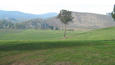
Photo taken from the site looking south over the Buchan River Valley. This photo shows the harder steeply bedded limestone,
called the Buchan Formation on the left on the far side of the valley and the softer marlstone, called the Murrindal Formation on the right
Soil Profile Morphology:
| Surface condition: | 20% cover of angular limestone boulders (up to 2 m), 20% rock outcrop |  | |
| Surface soil: | |||
| 0 – 0/55 cm | Dark reddish brown (5YR3/3) medium clay; strong medium blocky structure; firm consistence, moist; abundant (50-90%) angular limestone pebbles (up to 60 mm); abrupt and broken change to: | ||
| Underlying rock: | |||
| R | 0/55+ cm | Limestone | |
Key Profile Features:
- Variable depth of soil above the hard rock.
Soil Profile Characteristics:
| - | pH | Salinity | ||
Surface (A1 horizon) | Slightly alkaline | Very low | Non sodic | None |
Chemical and Physical Analysis:
Horizon | Horizon Depth (cm) | pH (water) | pH (CaCl2) | EC dS/m | Exchangeable Cations | Coarse Sand (0.2-2.0 mm) % | Fine Sand (0.02-0.2 mm) % | Silt (0.002-0.02 mm) % | Clay (<0.002 mm) % | Field Capacity % w/w | Wilting Point % w/w | |||
Ca | Mg | K | Na | |||||||||||
meq/100g | ||||||||||||||
A1 | 40-50 | 7.9 | 7.3 | 0.1 | 22 | 0.57 | 0.32 | 0.15 | 3 | 15 | 15 | 62 | 37.0 | 21.9 |
Management Considerations
- Plant available water is considered to be high, estimated at 105 mm for a soil depth of 55 cm. Because of variability in the depth of soil, plant growth is likely to be uneven.
- The soil has a high nutrient holding capacity (based on the sum of the exchangeable basic cations).
- As the soil is slightly alkaline, no additional lime is needed.
Profile Described By: David Rees and Grant Boyle, 2000.


