Timbarra (Symbol: Ta)
Profile No. 45 (Aldrick, et al 1992)
Geology
Palaeozoic granites, granodiorites, gneissic metamorphics and related some coarse crystalline plutonic rocks.
Landform
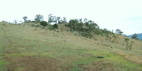
In the context of this report, the Timbarra map unit encompasses rolling to steep hills with an elevation range of about 60 to 700 m and an elevation range of 90 to 300 m. The slope gradients exceed 15% but are generally much steeper, commonly 30 – 50%. This Map unit may be subdivided into three components: moderate to steep slopes are the most extensive component, crests and narrow open depressions.

Original vegetation
Grassy woodland.
Soils
Component 1: Soils on moderate to steep slopes
The soils on the slopes are mostly shallow brown texture contrast soils with slightly acid sandy loam surfaces and slightly alkaline sandy clay subsoils. Weathering rock occurs before 1.2 m.
Component 2: Crests
The crests have varying amounts of exposed rock. The soils are believed to be similar to those described above but the depth to rock is shallower.
Component 3: Narrow open drainage lines
Aldrick et al. (1992) describes the soils as being quite variable, mainly brown or reddish brown sandy loam to sandy clay loam over stratified alluvium.
Profile No. 45 (Aldrick et al, 1992)
| Location: Ensay | Geo. Ref.: 577800E 5862200N |
| Australian Soil Classification: Haplic, Eutrophic, Red CHROMOSOL | Brown texture contrast soil |
| General landscape description: Steep low hills | |
| Geology: Palaeozoic granite | |
| Site description: Lower east facing slope (37% slope) | |
| Land use: Grazing on annual pasture | |
| Native vegetation: Open forest | |
| Map unit: Timbarra (previously mapped as Dargo, Component 1, but too steep for new unit definition) | |
Soil profile morphology
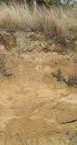
| Surface soil |  Typical shallow soil on granite south of Dargo Typical shallow soil on granite south of Dargo | ||
| A11 | 0-27 cm | Dark brown (7.5YR3/2); sandy loam; apedal; hard consistence, dry; 5% granite fragments up to 8 mm; clear wavy change to: | |
| A12 | 27-50 cm | Strong brown (7.5YR5/6); gritty sandy loam; apedal; hard consistence when dry; 15% granite fragments up to 8 mm; clear wavy change to: | |
| Subsoil | |||
| B2 | 50 -80 cm | Yellowish red (5YR5/6); sandy clay; moderate coarse (25 mm) angular blocky structure; firm consistence moist; 25% quartz and weathering feldspar crystals up to 3 mm and dark mica grains; | |
| C | 80 – 90+ cm | Strong brown (7.5YR5/6); sandy clay loam; moderate medium (20 mm) angular blocky structure; friable consistence moist; passing to weathering granite; | |
Key profile features
| |||
| Horizon | Depth cm | Field texture | pH water | EC dS/m | Gravel % | Coarse sand % | Fine sand % | Silt % | Clay % | Field cap. % w/w | Wilt. point % w/w | PAW* water % w/w |
| A11 | 0-10 | SL | 5.9 | <0.05 | 6 | 31 | 43 | 10 | 13 | |||
| A11 | 10-20 | SL | <0.05 | 12 | ||||||||
| A12 | 30-50 | SL | 6.7 | <0.05 | 22 | 37 | 42 | 11 | 11 | |||
| B2 | 60-80 | SC | 7.0 | <0.05 | 18 | 30 | 25 | 15 | 31 | |||
| C | 80-90 | SCL | 7.1 | <0.05 | 5 | 29 | 27 | 14 | 28 |
| Depth | OrgC# | Total N | Exch. Al | Exchangeable cations cmol (+) /kg | Ca:Mg | ESP | ||||||
| cm | % | % | ppm | Ca | Mg | K | Na | Total | H | CEC | ||
| 0-10 | 2.2 | 0.16 | 4.0 | 1.0 | 0.5 | 0.05 | 5.6 | 8.2 | 13.7 | 4 | ||
| 10-20 | ||||||||||||
| 30-50 | 4.4 | 0.8 | 0.3 | 0.08 | 5.6 | 2.2 | 7.8 | 5.5 | ||||
| 60-80 | 10.6 | 2.5 | 0.5 | 0.3 | 13.9 | 4.3 | 18.2 | 4.2 | 2 | |||
| 80-90 | 11.3 | 2.9 | 0.5 | 0.4 | 15.1 | 4.8 | 19.9 | 3.9 | 3 | |||
Management considerations
- As the soils are sandy, the plant available water capacity would be very low. However, plants would be able to utilise light rain after the soils are dry.
- Sheet and rill erosion would be high and common where the topsoil is exposed.
- Soil depth in the steep cleared drainage lines is likely to be very shallow with considerable exposed rock.


