Soil Features and Management
Profile Morphology | Topography | Soil Sodicity | Micro-Topography | Subsoil Salinity | Irrigation management | Permeability
Both soil profile and land surface features may, independently, determine suitability for irrigation. Such features, which include the permeability and salinity of profiles and the unevenness and slope of soil surfaces, may be effectively altered with regard to suitability for irrigation by appropriate management practices. In the Wimmera irrigation area, profile permeability and salinity vary with soil type. Surface features vary across the area as a whole. Unfortunately, in some areas, soils with desirable profile characteristics with regard to water relationships may occur where surface features are relatively unsuitable, while, in other areas the reverse situation exists. Again, any statement concerning suitability for irrigation is made more difficult by the particularly complex distribution of soil types in parts of the area.
Profile Morphology
Surface soil features which affect suitability for irrigation of perennial pastures include depth, variability and texture. Very shallow and hence easily erodible surface soils, as in Drung sandy clay loam, reduce suitability for irrigation. Variability in depth of surface soil, as in Drung sandy clay loam and, in particular, in Kalkee clay, will lead to uneven pasture growth. Surface soil texture is also extremely important with regard to soil water storage and to soil-plant water relationships. The heavier-textured clay surface soils of Bungalally clay, Horsham clay, Longerenong clay, Murtoa clay and Types A, B and E, are considered to be generally suitable with regard to irrigation of perennial pastures. These soil types have been placed in Crop Suitability Groups I and II. The lighter-textured sandy clay, sandy clay loam and sandy loam surface soils of Norton sandy clay, Drung sandy clay loam, Haven sandy clay loam, Drung sandy loam and Haven sandy loam, are considered to be less suitable. These soil types have been placed in Crop Suitability Groups III and IV.
Other physical features which vary with soil type and which may affect suitability for irrigation include surface and subsoil structure, seasonal behaviour of surface soils and water repellence. Water repellent sands are known to occur in the Haven and Quantong areas and may adversely affect infiltration. Brown Stringybark (E. baxterii) may be an indicator species for the occurrence of these sands (pers. comm. Alan Bedggood, NRE). The hard, non-friable surface clods of Longerenong clay, the powdery surface of Type C and the dense blocky subsoils of Drung sandy loam, Drung sandy clay loam and Haven sandy clay loam, are aspects of poor soil structure which contribute to poor profile permeability. The seasonally hard-setting nature of the surface soils of Drung sandy loam, Drung sandy clay loam, Haven sandy clay loam and Norton sandy clay, results in poor infiltration and ponding and reduces the suitability of these soil types for irrigation of perennial pastures. Other adverse results include poor germination and loss of cereal production in dryland agriculture.
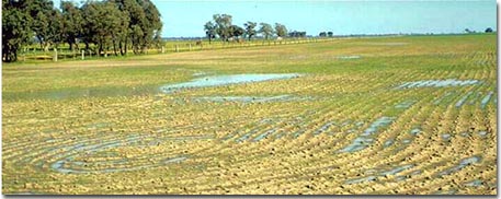
Ponding on hardsetting Red Sodosol north of Horsham.
As noted in a 1972 study (Martin, 1974), differences in surface soil structure between important soil types may have contributed to significant differences in grain yield obtained from a commercial wheat crop. In this observation the soils used were Kalkee clay, Murtoa clay and Drung sandy clay loam. Grain yield and total dry matter (determined using a 4 m2 quadrat) were significantly greater for Kalkee clay than for the other two soil types. There was no significant difference between Murtoa clay and Drung sandy clay loam. Data for the dry grain stage harvest are included in the table below.
Soil Type and Grain Yield
Soil Type | Grain Yield (g) | |
| Kalkee clay: | Range Mean | 67-118 94 |
| Murtoa Clay: | Range Mean | 46-81 64 |
| Drung sandy clay loam: | Range Mean | 26-78 54 |
| L.S.D. (0.05)* L.S.D. (0.05) | 16 21 | |
* [L.S.D.'s apply to the above means] | ||
Structural features of the surface soils are shown in the photographs below. The self-mulching condition of the Kalkee soil contrasts with the massive (when undisturbed) and epipedal (when disturbed) condition of the Murtoa soil and with the hard set condition of the Drung sandy clay loam soil. Plant roots were not observed beneath the immediate surface soils of Murtoa clay and Drung sandy clay loam.
Reference Site 33.
Self-Mulching Condition
Kalkee Clay
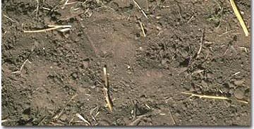
Reference Site 34.
Hard-Set Condition
Drung Sandy Clay Loam
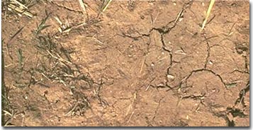
Reference Site 35.
Murtoa clay
Massive Condition
(Undisturbed State)
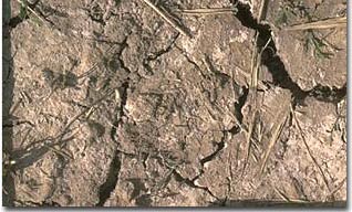
Reference Site 35.
Murtoa clay
Epipedal Condition
(Cultivated State)
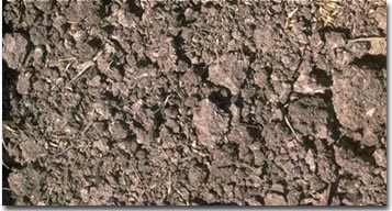
Other physical properties also differed. In terms of consistence, the Kalkee clay soil has a weak consistence (ie. friable). Murtoa clay has a strong to very strong consistence (ie. the dry aggregates are hard to crush). These differences in gross morphology may reflect, to some extent, differences in analytical data. The Kalkee surface soil was non-sodic and did not disperse. The Murtoa surface soil was sodic and moderately dispersive when remoulded, and the Drung sandy clay loam surface soil was sodic, slightly dispersive when dry and moderately dispersive when remoulded. Other data (Martin, unpublished) suggest higher densities (dry bulk densities) for Murtoa soil aggregates in comparison to those of Kalkee clay. Sunflower productivity differences associated with profile morphology (friable grey clays versus non-friable brown clays) have been reported by Badawy (1979). The grey clays were more productive in terms of grain and oil content.
Soil Sodicity
Soil chemical properties which vary with soil type include sodicity and salinity. The adverse effects of high sodicity on soil behaviour have been well documented. These effects include decreased saturated hydraulic conductivity with associated poor soil-plant water relations. Productivity problems caused by sodicity, and appropriate management strategies to overcome such problems, are discussed in detail by Ford et al. (1993) for dryland agriculture and by Rengasamy and Olsson (1993) for irrigated agriculture. Sodicity of representative profiles, and management implications, for the major soil types are discussed in Section 5. However, variation in this feature has been observed within some mapping units:
| (a) | Drung sandy clay loam surface soils are mainly non-sodic, upper subsoils vary from sodic to strongly sodic. Deep subsoils are mainly very strongly sodic. |
| (b) | Haven sandy loam surfaces are mainly non-sodic, upper subsoils are strongly sodic while deep subsoils vary from strongly sodic to very strongly sodic. |
| (c) | Horsham clay surfaces are mainly non-sodic, upper subsoils may be sodic and deep subsoils are sodic to very strongly sodic. |
| (d) | Kalkee clay surface soils are mainly non-sodic, upper subsoils are mainly sodic and deep subsoils strongly to very strongly sodic. |
| (e) | Murtoa clay surface soils are often sodic (but may be non-sodic), upper subsoils are sodic or strongly sodic and deep subsoils vary from strongly sodic to very strongly sodic. |
Dispersive behaviour is also variable. However, some trends between mapping units may exist. The surface soils of Kalkee clay are mainly non-dispersive, those of Horsham clay vary from non dispersive to moderately dispersive while those of Murtoa clay are mainly moderately dispersive. Upper subsoils of all of these units are moderately dispersive (rarely non-dispersive) and occasionally strongly or completely dispersive. Upper and deep subsoils of Haven sandy loam are often completely dispersive.
Subsoil Salinity
During the 1967 survey the distribution of salt in the soils was investigated to assess salinity hazards under irrigation. During the course of the field work some 1500 samples were taken from the same number of sites and analysed for chloride content. These analyses showed a complex variation across the area. However, on a morphological soil type basis, there were some significant differences. The four most numerically important soil types (ie. Drung sandy clay loam, Murtoa clay, Kalkee clay and Horsham clay), which together make up approximately 50 per cent of all soils sampled, were assessed as regards their relative salinities. The percent sodium chloride data, from 143 samples (60-90 cm depth) taken at random from each of the soil types, were analysed for statistical significance. Drung sandy clay loam was the only soil type with a mean per cent sodium chloride value within the range then considered "moderate" with regard to salinity hazard. This value was significantly higher than the values for the other soil types. The mean values for percent sodium chloride for the three clay soils were within the range then considered "low" with regard to salinity hazard. In this assessment, clay percent figures were not taken into account. The data is presented in the table below.
Morphological Soil Type and Per Cent Sodium Chloride.
Soil Type | - | Sodium Chloride % |
Drung sandy clay loam Murtoa clay Kalkee clay Horsham clay | Range Mean Range Mean Range Range Mean | 0.493-0.015 0.185 0.404-0.014 0.121 0.345-0.010 0.093 0.464-0.009 0.091 |
L.S.D. (0.05)* L.S.D. (0.01)* | - | 0.022 0.029 |
There has been general concern with flooding and associated soil salting (the process of accumulation of soluble salts in or on soils or in water (Shaw, 1988) in the Horsham area since at least the early 1950's. In 1971 the Water Commission's chief irrigation officer told district irrigators that he would "keep an eye" on salting on irrigated land. Concerns that flooding might increase salinity levels in Wimmera soils resulted in soil sampling being undertaken in 1975 to check for salting. It was concluded that a problem did not then exist on the Kalkee plains. By 1982 the water commission had completed the study "Horsham Flood Plain Management Study". Most of the "flood plain" as outlined in that report occurs on the prior stream flood plain landscape. The latest comprehensive report, "Wimmera Catchment Irrigation Area Salinity Management Strategy (1995)," reports approximately 1500 ha of salt affected land. Although current soil salinity levels will almost certainly differ from those obtained in the earlier 1953 and 1967 surveys, effects of soil types and environment through the passage of time may be illustrated using the Drung area as an example.
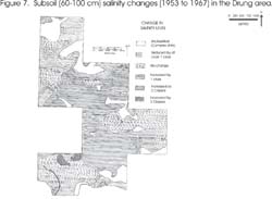
A subsoil (60-120 cm) salinity map of the Drung area was compiled from analyses obtained from 121 samples taken during the 1967 survey. Soil salinity classes are based on those of Shaw (1988) are determined on chloride percentage (expressed here as % NaCl) and clay percentage. Clay percentage figures varied between soil types so that the classes were checked for each of the main soil types.
Complex map units were not assessed. The map indicates that on an area basis the dominant subsoil salinity class was "medium". On a generalised soil type basis, Bungalally clay and Horsham clay averaged within the "medium" subsoil salinity range. Drung sandy loam and Murtoa clay averaged within the "high" subsoil salinity range. Salinity ranges (chloride as sodium chloride %) for the soil types are given in the table below. Clay percentage figures for Drung sandy loam samples differed in 1953 and 1967 so that different ranges were used for each year.
Soil Type and Salinity Class Reference
Soil Salinity Rating (Classes) | Bungalally clay Horsham clay Murtoa clay | Drung sandy loam | |||
1953 | 1967 | ||||
Very low Low Medium High Very High Extreme | < 0.046* 0.046 to 0.090 0.091 to 0.215 0.216 to 0.363 0.364 to 0.578 > 0.578 | < 0.031 0.031 to 0.061 0.062 to 0.149 0.150 to 0.248 0.249 to 0.462 > 0.462 | < 0.020 0.021 to 0.041 0.042 to 0.099 0.100 to 0.165 0.166 to 0.264 < 0.264 | ||
A comparison was made between this 1967 data and analyses from samples obtained during the earlier 1953 survey, again using Shaw's salinity classes. The level of change of different areas was rated as follows: reduced by one salinity class, no change, increased by one class, by two classes and by three classes. This system forms the legend of the accompanying map, (Figure 7) which shows considerable variation across the area. Some of the northern parts show a reduction in salinity class although much of the central area shows either no change or an increase in salinity level. On a generalised soil type basis, average salinity levels for Bungalally clay, Drung sandy loam and Horsham clay did not vary outside their class range. However, the data suggest that Murtoa clay increased from a medium to a high salinity rating.
Permeability
A profile associated feature of the greatest importance in soil and land management is permeability. Soil permeability is controlled by the potential to transmit water (ie. saturated hydraulic conductivity) of the least permeable soil layer (McDonald et al., 1990). Although measurements of hydraulic conductivity were not carried out during the 1967 survey, field measurements were made on several soils in 1973 (Stan Bridley, personal communication). Some of the results are included in the table below. This data may be of use in the context of more recent work. While accurate site locations are not known, seven sites were situated within generalised soil types. Horsham clay and Kalkee clay were rated as "moderately" permeable and Bungalally clay as "slowly permeable".
Generalised Soil Type and Permeability
| Generalised Soil Type | Irrigation Area | Water Table Depth (m) | Hydaulic Conductivity (mm/day) | Permeability Rating |
| 1. Bungalally Clay | Drung | 0.3 | 27 | Slow |
| 2. Horsham Clay | Youngs | 0.6 | 146 | Moderate |
| 3. Horsham Clay | Drung | 0.3 | 256 | Moderate |
| 4. Horsham Clay | Drung | 0.1 | 85 | Moderate |
| 5. Horsham Clay | Drung | 0.3 | 91 | Moderate |
| 6. Kalkee Clay | Riverside | 0.3 | 320 | Moderate |
| 7. Kalkee Clay | Riverside | 0.4 | 98 | Moderate |
It should be noted that even though some surface soils may be permeable (eg. Haven soil types), subsoil permeability may be so low that extensive flooding may occur after sustained winter rain.
Topography
Topographic features in an area may be such as to take precedent over otherwise desirable profile features, and reduce the suitability of the area for irrigation. Gently undulating slopes, which are a feature of areas of Kalkee clay soils, may make layout for irrigation difficult. In some areas of Quantong sand, moderate to steep slopes, which would require grading as an additional management practice, would reduce the suitability of the areas for irrigation. To the extent that some soils, otherwise considered to be very good for irrigated perennial pastures, occur in local depressions, the suitability of those soils is reduced. Such soils include Bungalally clay, Murtoa clay and Types A and B. The broad landscape positions of soils will also greatly affect their suitability for irrigation, soils of areas liable to flooding, or to isolation by flooding, as in parts of the river frontage landscape unit, are not recommended for irrigation. Soils which occur in such areas include Haven sandy loam, Haven sandy loam shallow phase, Murtoa clay, Norton sandy clay, Quantong sand, Quantong sand shallow phase and Type D.
Micro-Topography
A sometimes spectacular feature of micro-topography is the phenomenon of 'gilgai microrelief'. This feature is common in areas with Vertosols and results in an irregular land surface with alternating mounds and depressions. There are a variety of forms of gilgai which have been classified mainly on the shape and dimension of the mounds and depressions. The type which commonly occurs in the Wimmera is the "normal" form in which "the mounds and shelves are more or less equally developed and show no particular orientation" (Stace, 1968). Gilgai are also referred to as 'crabholes'.
Gilgai microrelief is formed due to clay horizons shrinking and swelling with alternate wetting and drying which forces 'blocks' of subsoil material gradually upwards to form mounds. The soil on the mounds therefore have properties which can be more like subsoils of Vertosols (ie. lighter colour, more alkaline, presence of carbonate, higher salinity). Continuous cultivation of paddocks has resulted in the smoothing out of many of these formations. The forces that created them, however, are still operating as is evident by the displacement of fence posts, and if the land is left undisturbed for a number of wetting and drying seasons they will re-form. In areas with gilgai microrelief crop and pasture growth is likely to be uneven across a paddock due to soil variations and poor drainage conditions in depressions.

Variable crop growth on the levelled surface of a Vertosol near Horsham.
Uneven crop growth is often seen during typical spring 'drying-off' stages when differences in profile morphology are reflected in critical moisture differences between mounds and depressions. The photograph above illustrates growth differences in a crop just north of Horsham.
Where the surface is left relatively undisturbed (eg. in a perennial pasture situation), the natural pattern of developed mounds and depressions may be seen, as in the accompanying photography of a pasture 18 km south of Horsham.
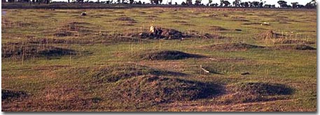
Pasture on gilgai south of Horsham.
Irrigation Management
Major management activities which alter soil surface and soil profile form may also alter suitability for irrigation. Laser grading is justified to the extent that it reduces the development and spread of salinity through facilitating better control of water application on land. However, the philosophy with regard to improved efficiency assumes constant soil infiltration and permeability characteristics across individual irrigation bays. The extent to which these hydrological characteristics are constant across an area, is in part at least a function of the uniformity of soil profile morphology (eg. texture profile) across the area in question. If a bay is initially uniform with regard to profile morphology then systematic grading may well maintain a uniform soil system. However, large scale soil surveys completed before the introduction of laser levelling reported considerable spatial variation in soil profile morphology across the irrigation region. Where such variation is not taken into account in the levelling process, there may be less confidence in the uniformity of profile morphology and hence in hydrological characteristics of the bay. For situations where surface soils are removed and subsoils are sodic, it may be advantageous to treat the exposed subsoils with gypsum before replacing the surface soil (ie. 'topsoiling'). However, in some areas it may still be difficult to account for variable surface soil depth.

