
A Study of the Land in the Grampians Area
To view the information PDF requires the use of a PDF reader. This can be installed for free from the Adobe website (external link).
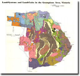
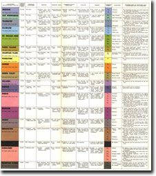
| Horsham (PDF 145KB) Warratong (PDF 218KB) Brimpaen (PDF 139KB) East Wonwondah (PDF 158KB) Dunkeld (PDF 218KB) | Kowree (PDF 209KB) Ararat (PDF 208KB) Parrie Yalloak (PDF 199KB) Dundas (PDF 201KB) Darracourt (PDF 191KB) | Telangatuk (PDF 208KB) Moora Valley (PDF 275KB) Mirranatwa (PDF 197KB) Grampians Ranges (PDF 257KB) | Ullswater (PDF 181KB) Willaura (PDF 178KB) Mt Dryden (PDF 150KB) Mt William Creek (PDF 163KB) |
 | Summary (PDF 103KB) | |
| Part I (PDF 230KB) | ||
| 1. Purpose of the Survey 2. Area of the Survey | ||
| Part II (PDF 1.6MB) | ||
| 3. Climate 4. Geology and Physiography 5. Soils 6. Native Vegetation | ||
| Part III (PDF 427KB) | ||
| 7. Present Land-Use 8. Soil Erosion | ||
| Part IV (PDF 1.5MB) | ||
| 9. The Edological Survey adn its Environmental Patterns Note: For individual land systems, see list above | ||
| Part V General Assessment of the Area (PDF 304KB) | ||
| 28. General Assessment of the Area | ||
| Part VI Acknowledgements, References, Appendices, Indices (PDF 1.0MB) |
© State of Victoria (Agriculture Victoria) 1996 - 2025.

This work, Victorian Resources Online, is licensed under a Creative Commons Attribution 4.0 licence. You are free to re-use the work under that licence, on the condition that you credit the State of Victoria (Agriculture Victoria) as author, indicate if changes were made and comply with the other licence terms.
The licence does not apply to ‘branding’ or some ‘images or photographs’ that may be owned by third parties. We ask you to seek prior approval to use images using the VRO feedback form. Access to higher quality images can also be provided on request.
This page was last updated on 25/01/2019.