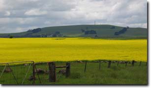
Mount Gellibrand
|
This information has been obtained from the report: Eruption Points of the Newer Volcanic Province of Victoria by Neville Rosengren. This report was published in 1994 and was prepared for the National Trust of Australia (Victoria) and the Geological Society of Australia (Victorian Division). The review of eruption points was based on an earlier unpublished manuscript Catalogue of the post-Miocene volcanoes of Victoria compiled by O P Singleton and E B Joyce (Geology Department, University of Melbourne 1970). |
| Location: | 38 14 00S 143 47 30E (external link); 7621-1-3 (Ombersley) 443645. 20 km NE of Colac. Mount Gellibrand Road. Colac. |  View to Mt Gellibrand. |
Land Tenure/Use: | Private land. Grazing and farm buildings, outcrop abundant at base. | |
Type 9: | Composite scoria cones overlying lava flows. A low and irregular dome of scoria resting on a lava shield with stony rise lava flows from the base. | |
261 m; 105 m. | ||
| Regional: | A clear and large scale example of the varied volcanic processes which have built the broad lava plains on the eastern edge of the Western District Plains. | |
 Mt Gellibrand. |
The report: Soil and Pasture Studies in the Mount Gellibrand Area, Western District of Victoria was prepared by G.W Leeper, Ann Nicholls and S.M Wadham in 1936 - reprinted from the Proceedings of the Royal Society of Victoria (Vol. 49). This survey is of significance in that it was one of the first soil surveys ever undertaken in Victoria. The section on associated vegetation provides important information on the past distribution of plant species in relation to soil types.


