
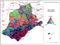
Radiometrics Image
Radiometric surveys measure the gamma rays emitted by the decay of radioactive isotopes within the top few centimetres of the Earth’s surface. The surveys are usually conducted using low-flying aircraft fitted with instruments (called scintillometers) that detect the radiation. The response varies with the mineralogy of soil and rock types, ground cover, moisture conditions at the surface, altitude of the instrument (flying height) and the type of detector and its specifications. Radiometric data are often ‘noisy’ and adjoining surveys flown at different times and with different survey specifications are difficult to mesh.
The data is collected in four bands (or channels):
Total count is the complete energy spectrum measured by the instrument, usually 256 channels between 0.5 MeV and 3.0 MeV. The data is usually presented in units of nanoGrays per hour (nGy/h).
Potassium measures the part of energy spectrum which relates to the decay of K40 isotopes. It is usually presented in units of equivalent percent (%). The potassium response varies with the mineralogy of the soils and rocks at the Earth’s surface. Potassic minerals include some feldspars (especially orthoclase), muscovite mica, illite and some montmorillonite clays.
Thorium measures the component of the energy spectrum which relates to the decay of Th232 isotopes, and is usually presented in units of equivalent parts per million (ppm). Monazite, thorianite, thorite and xenotime are among the thorium-rich minerals usually present in granites.
Uranium measures the window of the energy spectrum used to detect the decay of U238 isotopes, and is usually presented in equivalent parts per million (ppm). Typically, the uranium channel is the most ‘noisy’ as many rocks contain small amounts of uranium minerals such as uraninite and torbernite.
|
Geophysical data was sourced from several geophysical surveys conducted by the Australian Geological Survey Organisation and the Geological Survey of Victoria. These datasets were compiled and processed (gridded, stitched and levelled) in August 2001 by David Bibby, Data Manager, Geophysics Section, DPI's Geological Survey of Victoria. The radiometric ratio image has been draped on the terrain model to highlight the relationship between the radiometric signal and the landscape units in the Corangamite region. | ||
North of Lake Corangamite the dominance of green shows that the relative proportion of thorium is more than potassium or uranium. This is probably due to the inclusion of thorium-rich minerals in the soils, possibly derived from the granites exposed around Lismore. Some minerals containing relatively high proportions of radioactive thorium are more durable and often found in beach sands e.g. Monazite, Xenotime. The strand-lines left behind by a retreating sea during the Pliocene can be seen in the south west of the region. | ||
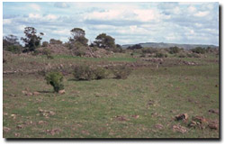 Stony Rise Landscape |
© State of Victoria (Agriculture Victoria) 1996 - 2025.

This work, Victorian Resources Online, is licensed under a Creative Commons Attribution 4.0 licence. You are free to re-use the work under that licence, on the condition that you credit the State of Victoria (Agriculture Victoria) as author, indicate if changes were made and comply with the other licence terms.
The licence does not apply to ‘branding’ or some ‘images or photographs’ that may be owned by third parties. We ask you to seek prior approval to use images using the VRO feedback form. Access to higher quality images can also be provided on request.
This page was last updated on 23/03/2020.