
Elevation
|
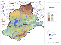
This elevation map provides a broadscale overview of the relief across the region. The Digital Elevation Model (DEM) was derived from 1:25 000 topographic data, including contours, spot heights, hydrology (stream enforced) and shore boundaries using ANUDEM software. The interpolation of topographic data is to a 20 m x 20 m grid, which has been resampled to 100 m cell size for display on this website. Source: Dahlhaus (2002) Dahlhaus, P. 2002. Corangamite Catchment Management Authority - Atlas of GIS data. April 30th, 2002. | |
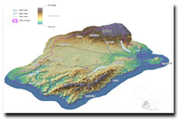 Elevation - 3D image. |
© State of Victoria (Agriculture Victoria) 1996 - 2025.

This work, Victorian Resources Online, is licensed under a Creative Commons Attribution 4.0 licence. You are free to re-use the work under that licence, on the condition that you credit the State of Victoria (Agriculture Victoria) as author, indicate if changes were made and comply with the other licence terms.
The licence does not apply to ‘branding’ or some ‘images or photographs’ that may be owned by third parties. We ask you to seek prior approval to use images using the VRO feedback form. Access to higher quality images can also be provided on request.
This page was last updated on 23/03/2020.