
Soil/Landform Unit - Wartook granite hills
Landform Unit Description
Page top
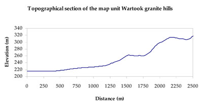
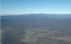 Slopes on the western margin of the Wartook syncline |
0.10% of CMA region Hills and footslopes at Wartook on the north-western edge of the Grampian Ranges are part of the Dissected Western Uplands. This granite hill landscape with rocky crests abuts the western extent of the Grampians Range and extensive plains associated with the MacKenzie River to the west. Footslopes, steep hillslopes and crests (with rock outcrop), and drainage lines occur in these hills. Drainage is concentrated from the steeper slopes, dissecting a number of colluvial slopes/fans then extending west to the MacKenzie River. Soil type is predominantly yellow texture contrast soils (Chromosols), sometimes sodic (Sodosols) on the lower slopes. There are also thin sandy and minor deeper sandy soils (Rudosols and Tenosols). Sheet, rill and gully erosion are the major land degradation threats, with wind erosion of light topsoils possible where exposed. This unit is used for grazing (sheep, beef cattle), water supply function in some areas, as well as nature conservation and recreation. Vegetation is largely either woodland or forest. Some vegetation communities present include Shrubby Woodland, Herb-rich Heathy Forest, Hills Herb-rich Woodland, Plains Grassy Woodland, Heathy Woodland, Heathy Dry Forest, Grassy Dry Forest and Damp Sands Herb-rich Woodland. | 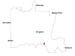 |
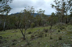 Hillslopes near Wartook with granite outcrop and native vegetation | 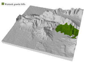 |
 | 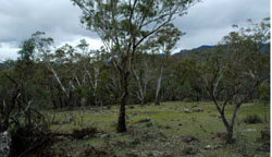 Granitic hillslopes near Wartook |
Component | 1 | 2 | 3 |
Proportion of soil-landform unit | 15% | 10% | 75% |
| CLIMATE Rainfall (mm) | Annual: 765 | ||
| Temperature (oC) | Minimum 8, Maximum 20 | ||
| Precipitation less than potential evapotranspiration | October–March | ||
| GEOLOGY Age and lithology | Quaternary alluvium, gravel, sand, silt; Devonian granite (Mackenzie River Granodiorite); Quaternary colluvium, gravel, sand and silt; Silurian marine sandstone, minor conglomerate and siltstone (Grampians Group) | ||
| Geomorphology | |||
| LANDUSE | Uncleared areas: water supply; nature conservation; recreational activities Cleared areas: sheep and beef cattle grazing; water supply | ||
| TOPOGRAPHY Landscape | Moderate–steep hills | ||
| Elevation range (m) | 207–649 | ||
| Local relief (m) | 100–250 | ||
| Drainage pattern | Dendritic | ||
| Drainage density (km/km2) | 1.5 | ||
| Landform | Hillslopes | ||
| Landform element | Steep hillslope | Drainage line | Footslope |
| Slope and range (%) | 25 (10-32) | 2 (0-4) | 5 (1-10) |
| Slope shape | Convex | Concave | Concave |
| NATIVE VEGETATION Ecological Vegetation Class | Hills Herb-rich Woodland (21.0%), Damp Sands Herb-rich Woodland (18.9%), Plains Grassy Woodland (17.1%), Heathy Woodland (10.6%), Other (30.4%) | ||
| SOIL Parent material | In situ intrusive granite | Fluvial gravel, sand and silt | Fluvial gravel, sand and silt, intrusive granite |
| Description (Corangamite Soil Group) | Yellow texture contrast soils (3) | Yellow texture contrast soils (3) | |
| Soil type sites | |||
| Surface texture | Silty loam (sandy) | Silty loam (sandy) | Silty loam (sandy) |
| Permeability | Moderate | Very slow | Slow |
| Depth (m) | < 1 | > 2 | 1.4 |
| LAND CHARACTERISTICS, POTENTIAL AND LIMITATIONS Critical land features, processes, forms | Light loose surface soils that may be susceptible to wind, sheet and rill erosion in drier areas (including drier aspects). Susceptible to acidification in wetter areas. | Light loose surface soils that are susceptible to gully erosion. Poor subsurface drainage, particularly on flats and depressions. Surface soils susceptible to acidification. | Light loose surface soils that may be susceptible to wind, sheet and rill erosion in drier areas (including drier aspects). Poor subsurface drainage, particularly on flats and gentle slopes. Susceptible to acidification in wetter areas. |
© State of Victoria (Agriculture Victoria) 1996 - .

This work, Victorian Resources Online, is licensed under a Creative Commons Attribution 4.0 licence. You are free to re-use the work under that licence, on the condition that you credit the State of Victoria (Agriculture Victoria) as author, indicate if changes were made and comply with the other licence terms.
The licence does not apply to ‘branding’ or some ‘images or photographs’ that may be owned by third parties. We ask you to seek prior approval to use images using the VRO feedback form. Access to higher quality images can also be provided on request.
This page was last updated on .