
Soil/Landform Unit - Rocky Point low hills and rises
Landform Unit Description
Page top
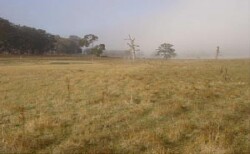
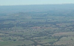 Undulating rises west of Rocky Point and Mount Ararat |
0.18% of CMA region Rises and low hills west of Ararat fall on the southern boundary of the Wimmera CMA region. This rise and low hill complex is part of the Dissected Western Uplands with a landscape chiefly derived on granite and Cainozoic sediments. The terrain abuts associated ridges and valleys of Palaeozoic metasediments of the Ararat Hills. Rise slopes comprise pronounced upper and lower segments with hillslopes and crests, with prominent drainage depressions and associated drainage lines. Drainage dissects this landscape, concentrating flow from the Ararat Hills to the east. Yellow sodic texture contrast soils (Sodosols) occur mainly on the lower slopes and flats (less drainage). Sheet and rill erosion are potential land degradation threats given the texture contrast nature of soils. Gully erosion and salting is also prominent. Used mainly for grazing (sheep, beef cattle), with occasional dryland cropping on the flats and lower slopes. Native vegetation communities including Grassy Dry Forest, Alluvial Terraces Herb-rich Woodland, Granitic Hills Woodland and Grassy Woodland exist on these rises and low hills. |  |
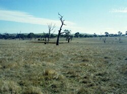 Lower slopes and drainage depressions |  |
 |  Natural springs occur in valley floors |
Component | 1 | 2 | 3 | 4 |
Proportion of soil-landform unit | 15% | 10% | 55% | 20% |
| CLIMATE Rainfall (mm) | Annual: 790 | |||
| Temperature (oC) | Minimum 7, Maximum 18 | |||
| Precipitation less than potential evapotranspiration | October–March | |||
| GEOLOGY Age and lithology | Devonian granite (Ararat granodiorite); Neogene fluvial gravel, sand and silt; Cambrian basalt, andesite, boninite, rhyolite, gabbro and lithics | |||
| Geomorphology | ||||
| LANDUSE | Uncleared areas: nature conservation Cleared areas: sheep and beef cattle grazing; dryland cropping | |||
| TOPOGRAPHY Landscape | Undulating rises and low hills | |||
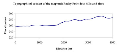
| Elevation range (m) | 252–402 | |||
| Local relief (m) | 40 | |||
| Drainage pattern | Dendritic | |||
| Drainage density (km/km2) | 1.9 | |||
| Landform | Drainage depressions | Low hills | Rises | |
| Landform element | Drainage line | Hillslope and crest | Upper slope | Lower slope |
| Slope and range (%) | 1 (0-3) | 15 (10-32) | 6 (3-15) | 4 (2-8) |
| Slope shape | Concave | Convex | Convex | Concave |
| NATIVE VEGETATION Ecological Vegetation Class | Granitic Hills Woodland (60.3%), Alluvial Terraces Herb-rich Woodland (29.1%), Other (10.6%) | |||
| SOIL Parent material | Fluvial gravel, sand and silt | In situ intrusive granite | In situ intrusive granite | In situ intrusive granite, fluvial sand, silt and clay |
| Description (Corangamite Soil Group) | Sodic yellow texture contrast soils (4) | Yellow texture contrast soils (3) | Yellow texture contrast soils (3) | |
| Soil type sites | ||||
| Surface texture | Sandy clay loam | Silty loam (sandy) | Silty loam (sandy) | Sandy clay loam |
| Permeability | Very slow | Slow to moderate | Slow to moderate | Slow |
| Depth (m) | > 2 | 1.2 | 1.6 | > 2 |
| LAND CHARACTERISTICS, POTENTIAL AND LIMITATIONS Critical land features, processes, forms | Light loose surface soils susceptible to wind, sheet and rill erosion. Sodic subsoil extremely susceptible to gully erosion. Poor subsurface drainage, particularly on flats and drainage depressions. Surface soils susceptible to acidification. | Light loose surface soils that may be susceptible to wind, sheet and rill erosion in drier areas (including drier aspects). Susceptible to acidification in wetter areas. | Light loose surface soils that may be susceptible to wind, sheet and rill erosion in drier areas (including drier aspects). Susceptible to acidification in wetter areas. | Light loose surface soils susceptible to wind, sheet and rill erosion. Sodic subsoil susceptible to gully erosion. Poor subsurface drainage leads to waterlogging on flats and break of slope. Surface soils susceptible to acidification. |
© State of Victoria (Agriculture Victoria) 1996 - .

This work, Victorian Resources Online, is licensed under a Creative Commons Attribution 4.0 licence. You are free to re-use the work under that licence, on the condition that you credit the State of Victoria (Agriculture Victoria) as author, indicate if changes were made and comply with the other licence terms.
The licence does not apply to ‘branding’ or some ‘images or photographs’ that may be owned by third parties. We ask you to seek prior approval to use images using the VRO feedback form. Access to higher quality images can also be provided on request.
This page was last updated on .