
Soil/Landform Unit - Navarre foothills
 Navarre Hill with gentle to undulating rises and slopes surrounding |
0.50% of CMA region This unit consists of an undulating terrain complex that forms part of the upper Wimmera northern catchment boundary. This rise and low hill unit is part of the hills, valley slopes and plains on non-granitic Palaeozoic rocks subdivision of the Dissected Western Uplands (2.1.2). These undulating rises and low hills of Palaeozoic and Cainzoic sediments drain into upper alluvial and colluvial units (Wattle Creek unit) and the Wimmera River valley (Drung unit) further downstream. Hillslopes share prominent upper and lower slopes, crests and drainage lines. Soils are relatively well drained and are predominantly red texture contrast soils (Chromosols) with yellow, brown and grey texture contrast soils generally sodic (Sodosols) on the lower slopes and poorer drainage areas. Sheet and rill erosion are major land degradation susceptibilities given slope and soil (texture contrast, dispersive). Gully erosion is a factor on lower slopes with greater depth of unconsolidated material. Grazing (sheep and some cattle) is the major enterprise with occasional cropping on lower gentler slopes. Remnant vegetation consists of Heathy Dry Forest, Box Ironbark Forest, Grassy Woodland, Riparian Woodland and Plains Woodland. | 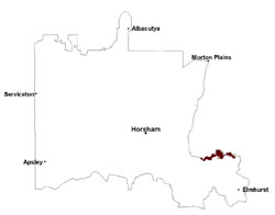 |
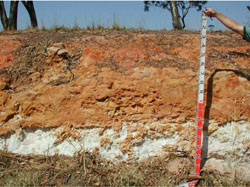 Parilla Sand over kaolinised palaeozoic bedrock | 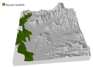 |
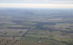
 | 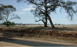 Gentle rise cutting east of Campbells Bridge |
Component | 1 | 2 | 3 | 4 |
Proportion of soil-landform unit | 10% | 45% | 30% | 15% |
| CLIMATE Rainfall (mm) | Annual: 530 | |||
| Temperature (oC) | Minimum 8, Maximum 20 | |||
| Precipitation less than potential evapotranspiration | September–April | |||
| GEOLOGY Age and lithology | Neogene fluvial gravel, sand and silt; Quaternary silt, sand and minor gravel (Shepparton Formation); Quaternary fluvial gravel, sand and silt | |||
| Geomorphology | ||||
| LANDUSE | Uncleared areas: nature conservation Cleared areas: dryland cropping; sheep and beef cattle grazing | |||
| TOPOGRAPHY Landscape | Undulating rises and foothills | |||
| Elevation range (m) | 188–331 | |||
| Local relief (m) | 10 | |||
| Drainage pattern | Dendritic | |||
| Drainage density (km/km2) | 0.8 | |||
| Landform | Undulating rises (Navarre 3) | Undulating plains (Navarre 1 and 2) | ||
| Landform element | Crest | Upper slope | Lower slope | Drainage line |
| Slope and range (%) | 3 (0-7) | 7 (3-20) | 4 (2-15) | 2 (0-15) |
| Slope shape | Convex | Convex | Straight | Concave |
| NATIVE VEGETATION Ecological Vegetation Class | Grassy Woodland (39.0%), Plains Woodland (18.8%), Heathy Dry Forest (14.6%), Box Ironbark Forest (14.6%), Other (6.1%) | |||
| SOIL Parent material | Marine sand and silt, minor sandstone, siltstone and biotite schist | Marine sand and silt, minor sandstone, siltstone and biotite schist | Fluvial gravel, sand and silt | Alluvial gravel, sand and silt |
| Description (Corangamite Soil Group) | ||||
| Soil type sites | ||||
| Surface texture | Fine sandy loam to sandy clay loam | Fine sandy loam to sandy clay loam | Sandy loam (silty) | Sandy loam (silty) |
| Permeability | Moderate to high | Moderate to high | Moderate | Moderate |
| Depth (m) | 0.7 | 1.2 | < 2 | > 2 |
| LAND CHARACTERISTICS, POTENTIAL AND LIMITATIONS Critical land features, processes, forms | Friable with better infiltration in moister areas, hardsetting and soft surfaces susceptible to sheet and rill erosion even on gentle slope due to impeding layer (clay or hardpan). Subsurface soil and upper subsoil susceptible to compaction, and also gully erosion where sodic and deep. Topsoil may be susceptible to acidification. | Friable with better infiltration in moister areas, hardsetting and soft surfaces susceptible to sheet and rill erosion even on gentle slope due to impeding layer (clay or hardpan). Subsurface soil and upper subsoil susceptible to compaction, and also gully erosion where sodic and deep. Topsoil may be susceptible to acidification. | Hardsetting and soft surfaces susceptible to sheet and rill erosion even on gentle slope due to impeding layer (clay or hardpan). Subsurface soil and upper subsoil susceptible to compaction, and also gully erosion where sodic and deep. Topsoil may be susceptible to acidification. | Hardsetting and soft surfaces susceptible to sheet and rill erosion even on gentle slope due to impeding layer (clay or hardpan). Subsurface soil and upper subsoil susceptible to compaction, and also gully erosion where sodic and deep. Topsoil may be susceptible to acidification. |
© State of Victoria (Agriculture Victoria) 1996 - .

This work, Victorian Resources Online, is licensed under a Creative Commons Attribution 4.0 licence. You are free to re-use the work under that licence, on the condition that you credit the State of Victoria (Agriculture Victoria) as author, indicate if changes were made and comply with the other licence terms.
The licence does not apply to ‘branding’ or some ‘images or photographs’ that may be owned by third parties. We ask you to seek prior approval to use images using the VRO feedback form. Access to higher quality images can also be provided on request.
This page was last updated on .