
Soil/Landform Unit - Murtoa flats
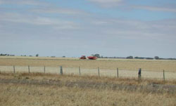
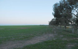 Alluvial plain east of Murtoa used for crops and remnant black box vegetation |
0.04% of CMA region Drainage/depositional entities near Murtoa form part of an extensive plains complex. This drainage unit is part of the clay plains with subdued ridges geomorphological unit (5.4). These low alluvial depressions and flats of Quaternary sediments are generally aligned north-south and lie just to the north of the Wimmera River alluvial plains, draining into Corkers Creek to the south. Dominated by the flats and drainage depressions, drainage is extensive away from the main drainage lines and depressions. Site drainage is generally very slow with soils including grey cracking clay soils (Vertosols), occasionally with pedal (structured) and self-mulching surfaces. Often hardsetting or cracking, gilgai micro relief is likely and generally topsoil depth is shallow. Seasonal inundation and waterlogging can occur. Compaction is also a susceptibility factor with these soils and topography. Broadacre dryland cropping is the major enterprise with minor grazing (sheep). The four main vegetation communities found are Riverine Chenopod Woodland, Lignum Wetland, Plains Grassland and Plains Savannah. | 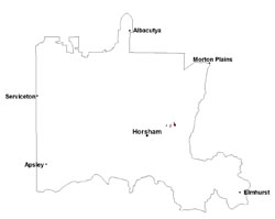 |
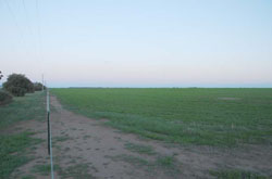 Alluvial plain crop and remnant vegetation along fenceline | 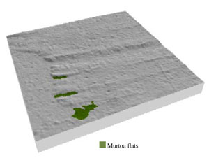 |
 |  Black box flats |
Component | 1 | 2 | 3 | 4 |
Proportion of soil-landform unit | 10% | 15% | 65% | 10% |
| CLIMATE Rainfall (mm) | Annual: 440 | |||
| Temperature (oC) | Minimum 8, Maximum 21 | |||
| Precipitation less than potential evapotranspiration | September–April | |||
| GEOLOGY Age and lithology | Neogene marine sand and silt (Parilla Sand); Quaternary fluvial silt, sand and minor gravel (Shepparton Formation) | |||
| Geomorphology | 4.2. Plains with leveed channels of the older alluvial plains | |||
| LANDUSE | Uncleared areas: nature conservation Cleared areas: dryland cropping; sheep and beef cattle grazing | |||
| TOPOGRAPHY Landscape | Subdued depression of older plain | |||
| Elevation range (m) | 129–138 | |||
| Local relief (m) | 2 | |||
| Drainage pattern | Dendritic | |||
| Drainage density (km/km2) | 0.8 | |||
| Landform | Gentle side slopes | Alluvial plains | ||
| Landform element | Upper slope | Long gentle lower slope | Flat and drainage depression | Drainage line |
| Slope and range (%) | 3 (1-8) | 2 (1-3) | 1 (0-2) | 0 (0-1) |
| Slope shape | Convex | Linear | Straight | Concave |
| NATIVE VEGETATION Ecological Vegetation Class | Plains Grassland (37.5%), Lignum Wetland (30.0%), Riverine Chenopod Woodland (12.8%), Other (2.6%) | |||
| SOIL Parent material | Marine sand and silt | Marine sand and silt | Fluvial gravel, sand and silt | Alluvial gravel, sand and silt |
| Description (Corangamite Soil Group) | Cracking and self-mulching clay soils (24) | Cracking and self-mulching clay soils (24) | ||
| Soil type sites | ||||
| Surface texture | Fine sandy loam to medium clay | Fine sandy loam to medium clay | Medium clay | Medium clay |
| Permeability | Moderate to slow | Slow | Slow | Very slow |
| Depth (m) | 1.5 | > 2 | > 3 | > 3 |
| LAND CHARACTERISTICS, POTENTIAL AND LIMITATIONS Critical land features, processes, forms | Hardsetting soil slightly susceptible to sheet and rill erosion. Soils are prone to compaction at critical moisture contents. Subsoil susceptible to gully erosion when exposed due to dispersive (sodic) nature. Slight susceptibility to acidification of surface soil. | Soils may be slightly susceptible to inundation and waterlogging where sandy surface soil is shallow. Hardsetting soil slightly susceptible to sheet and rill erosion. Soils are prone to compaction at critical moisture contents. Subsoil susceptible to gully erosion when exposed due to dispersive (sodic) nature. Slight susceptibility to acidification of surface soil. | Flats and drainage depressions susceptible to inundation and waterlogging, but can be variable due to micro relief (gilgai) and surface condition (self-mulching or epipedal). Surface soils friable and only slightly susceptible to wind erosion. Soils may be susceptible to compaction at critical moisture contents. | Drainage lines susceptible to inundation and waterlogging, especially from extensive flood events. Surface soils tend to be epipedal (massive) and only slightly susceptible to wind erosion. Soils may be susceptible to compaction at critical moisture contents. |
© State of Victoria (Agriculture Victoria) 1996 - .

This work, Victorian Resources Online, is licensed under a Creative Commons Attribution 4.0 licence. You are free to re-use the work under that licence, on the condition that you credit the State of Victoria (Agriculture Victoria) as author, indicate if changes were made and comply with the other licence terms.
The licence does not apply to ‘branding’ or some ‘images or photographs’ that may be owned by third parties. We ask you to seek prior approval to use images using the VRO feedback form. Access to higher quality images can also be provided on request.
This page was last updated on .