
Soil/Landform Unit - Kellalac ridge crests
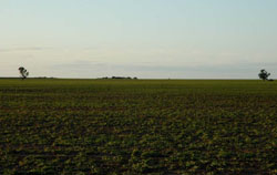 Low gentle slope near Dooen selectively cleared and used as pastoral runs |
0.11% of CMA region The Kellalac ridge crests soil-landform unit represents eroded surfaces of stranded beach ridges that occur east of the Wimmera River. Occurring within the clay plains with subdued ridges of the North West Dunefields and Plains (5.4), landforms include very gentle rise crests with subtle slopes and plains. Soils include sodic red texture contrast soils (Sodosols) on eroded ridge crests and cracking clay soils (Vertosols) through out. Land use across the Kalkee plains is cereal cropping with grazing and fodder production intermixed. Hardsetting soil surfaces may be susceptible to sheet and rill erosion along with wind erosion when exposed. The cracking clays are likely to have variable soil water drainage capacity owing to the micro relief (gilgai). Remnant vegetation includes vegetation communities such as Low Rises Woodland, Plains Grassland, Plains Woodland and Plains Savannah. | 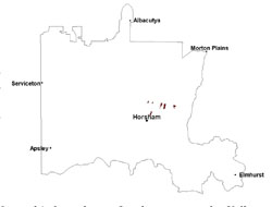 |
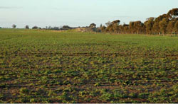
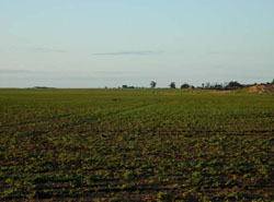 Midslope of a low gentle slope at Dooen | |
 |  Looking towards lower slope portion of landscape |
Component | 1 | 2 | 3 |
Proportion of soil-landform unit | 50% | 30% | 20% |
| CLIMATE Rainfall (mm) | Annual: 430 | ||
| Temperature (oC) | Minimum 8, Maximum 21 | ||
| Precipitation less than potential evapotranspiration | September–April | ||
| GEOLOGY Age and lithology | Neogene marine sand and silt (Parilla Sand); Quaternary fluvial silt, sand and minor gravel (Shepparton Formation) | ||
| Geomorphology | |||
| LANDUSE | Uncleared areas: nature conservation Cleared areas: dryland cropping; sheep grazing | ||
| TOPOGRAPHY Landscape | Low ridge crest and undulating plains | ||
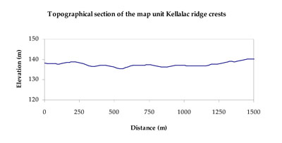
| Elevation range (m) | 129–148 | ||
| Local relief (m) | 7 | ||
| Drainage pattern | Dendritic | ||
| Drainage density (km/km2) | 1.0 | ||
| Landform | Eroded crests | Plains | |
| Landform element | Very gentle broad crest | Low gentle slope | Flat |
| Slope and range (%) | 2 (1-5) | 3 (0-6) | 0 (0-1) |
| Slope shape | Convex | Convex | Straight |
| NATIVE VEGETATION Ecological Vegetation Class | Plains Woodland (32.9%), Plains Savannah (31.7%), Low Rises Woodland (13.5%), Plains Grassland (6.4%) | ||
| SOIL Parent material | Aeolian sand | Marine sand and silt | Marine sand and silt |
| Description (Corangamite Soil Group) | Cracking clay soils (34) | Cracking clay soils (34) | |
| Soil type sites | |||
| Surface texture | Sandy loam to medium clay | Medium clay | Medium clay |
| Permeability | Moderate | Moderate | Moderate |
| Depth (m) | 1.5 | > 3 | > 3 |
| LAND CHARACTERISTICS, POTENTIAL AND LIMITATIONS Critical land features, processes, forms | Hardsetting upper soil susceptible to sheet and rill erosion along with wind erosion when exposed. High clay surfaces result in restricted soil drainage, but can be variable due to micro relief (gilgai). Dispersive and deep subsoils susceptible to gully erosion on steeper slopes. Compaction of upper soil variable depending on soil depth and moisture content. | High clay content results in restricted soil drainage, but can be variable due to micro relief (gilgai). Soils may be susceptible to inundation and waterlogging. Surface soils are friable and only slightly susceptible to wind erosion due to self-mulching and massive nature. Soils may be susceptible at critical moisture contents and have variable resilience to compaction. | High clay content results in restricted soil drainage, but can be variable due to micro relief (gilgai). Soils may be susceptible to inundation and waterlogging. Surface soils are friable and only slightly susceptible to wind erosion due to self-mulching and massive nature. Soils may be susceptible at critical moisture contents and have variable resilience to compaction. |
© State of Victoria (Agriculture Victoria) 1996 - .

This work, Victorian Resources Online, is licensed under a Creative Commons Attribution 4.0 licence. You are free to re-use the work under that licence, on the condition that you credit the State of Victoria (Agriculture Victoria) as author, indicate if changes were made and comply with the other licence terms.
The licence does not apply to ‘branding’ or some ‘images or photographs’ that may be owned by third parties. We ask you to seek prior approval to use images using the VRO feedback form. Access to higher quality images can also be provided on request.
This page was last updated on .