
Soil/Landform Unit - Kanawinka sandsheets and dunes
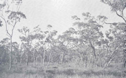 Seasonally wet soils with heath woodlands of manna, swamp, yellow or pink gums Seasonally wet soils with heath woodlands of manna, swamp, yellow or pink gums |
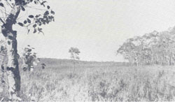
0.02% of CMA region Sandsheets and plains in the south-west corner of the Wimmera CMA region consist of sand dunes with gentle slopes and crests as well as sandsheets on plains with scattered swamps. As the only unit in the region to be part of the Western Plains, land use includes grazing by sheep and cattle along with irrigated agriculture where sandy surface soils are used as part of centre pivot systems. Soil profiles are sandy throughout except in swamps where cracking clays occur and on plains where deep sand overlies heavier subsoils as Sodosols. Remnant vegetation is largely either Plains Grassy Woodland or Damp Sands Herb-rich Woodland/Plains Swampy Woodland/Aquatic Herbland Mosaic vegetation community. The main form of land degradation is wind erosion where sandy surfaces lack sufficient ground cover. |  |
 Stringybarks with heath understorey | 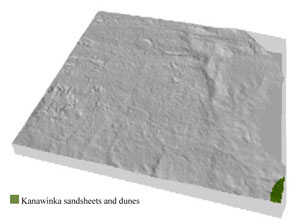 |
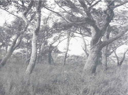
 |  Treeless heaths with sandy surface soils |
Component | 1 | 2 | 3 | 4 | 5 |
Proportion of soil-landform unit | 10% | 30% | 30% | 10% | 20% |
| CLIMATE Rainfall (mm) | Annual: | ||||
| Temperature (oC) | Minimum 8, Maximum 20 | ||||
| Precipitation less than potential evapotranspiration | October–April | ||||
| GEOLOGY Age and lithology | Neogene marine sand and silt (Parilla Sand); Quaternary aeolian dune sand, paludal silt and clay | ||||
| Geomorphology | |||||
| LANDUSE | Uncleared areas: nature conservation Cleared areas: dryland cropping; sheep and cattle grazing; irrigated horticulture; softwood plantations | ||||
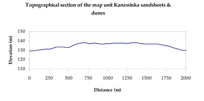
| TOPOGRAPHY Landscape | Sandsheets and dunes | ||||
| Elevation range (m) | 126–139 | ||||
| Local relief (m) | 5 | ||||
| Drainage pattern | Dendritic | ||||
| Drainage density (km/km2) | 0.3 | ||||
| Landform | Low lying regular dunes | Plains and swamps | |||
| Landform element | Gentle dune crest | Dune slope | Plains and gentle slope | Swamp bed | Sandsheet |
| Slope and range (%) | 2 (0-8) | 3 (1-15) | 3 (1-7) | 0 (0-1) | 2 (1-5) |
| Slope shape | Convex | Concave | Straight | Concave | Straight |
| NATIVE VEGETATION Ecological Vegetation Class | Plains Grassy Woodland (33.3%), Damp Sands Herb-rich Woodland/Plains Swampy Woodland/Aquatic Herbland Mosaic (33.3%) | ||||
| SOIL Parent material | Aeolian sand and silt | Aeolian sand and silt | Paludal silt and clay | Paludal silt and clay | Aeolian sand and silt |
| Description (Corangamite Soil Group) | Sandy soils with and without pans (31) | Sodic brown, yellow and grey texture contrast soils (38) | Grey and brown cracking clay soils (37) | Sodic brown, yellow and grey texture contrast soils (38) | |
| Soil type sites | LSWW11, LSWW17, LSWW13 | LS3, LSWW9, LSWW5 | LSWW11, LSWW17, LSWW13 | ||
| Surface texture | Sand | Loamy sand | Loamy sand | Medium clay | Loamy sand |
| Permeability | High | High | Moderate | Slow | Moderate |
| Depth (m) | > 1.5 | > 1.5 | 1.3 | > 2 | 1.3 |
| LAND CHARACTERISTICS, POTENTIAL AND LIMITATIONS Critical land features, processes, forms | Soils with low organic matter levels can be susceptible to wind and sheet erosion where exposed. Low inherent soil fertility. | Soils with low organic matter levels can be susceptible to wind and sheet erosion where exposed. Low inherent soil fertility. | Susceptible to wind and sheet erosion where exposed and surfaces with little organic matter. Susceptible to compaction where hardsetting and restricted drainage. Upper soil is susceptible to acidification. | Susceptible to seasonal inundation and waterlogging. Slightly susceptible to surface sheet erosion where soils are exposed. Surface soils friable and only slightly susceptible to wind erosion. Soils susceptible to compaction at critical moisture contents. | Susceptible to wind and sheet erosion where exposed and surfaces with little organic matter. Susceptible to compaction where hardsetting and restricted drainage. Upper soil is susceptible to acidification. |
© State of Victoria (Agriculture Victoria) 1996 - .

This work, Victorian Resources Online, is licensed under a Creative Commons Attribution 4.0 licence. You are free to re-use the work under that licence, on the condition that you credit the State of Victoria (Agriculture Victoria) as author, indicate if changes were made and comply with the other licence terms.
The licence does not apply to ‘branding’ or some ‘images or photographs’ that may be owned by third parties. We ask you to seek prior approval to use images using the VRO feedback form. Access to higher quality images can also be provided on request.
This page was last updated on .