
Soil/Landform Unit - Harrow dissected valley
 Red gum plains that graduate into the dissected valley of the Glenelg River to the south |
0.11% of CMA region Located on the southern Wimmera CMA boundary, the Harrow valley soil-landform unit forms part of the Low Elevation Plateaux of the Dundas Tablelands. While the unit is relatively gentle in the Wimmera CMA region, the terrain is steeper and undulating further south as the unit lines the Glenelg River. Comprising escarpments and plains, the landscape is dominated by cereal and fodder production with sheep and cattle grazing also prominent. Soils are brown and yellow texture contrast soils (Chromosols) that may have variable amounts of buckshot present. Soil compaction along with acidification constitute major soil degradation threats on plains that can be prone to periodic waterlogging. Vegetation communities that have been recorded on plains and escarpments include Heathy Woodland and Shallow Sands Woodland on dry well-drained soils of escarpments and plains. Plains Sedgy Woodland and Seasonally Inundated Shrubby Woodland can be found on poorly drained soils. | 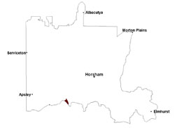 |
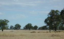
 Dissected undulating plain as seen looking across paddock near Douglas | 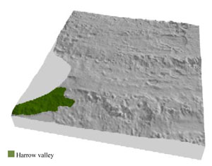 |
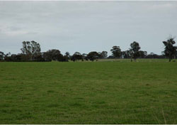
 | 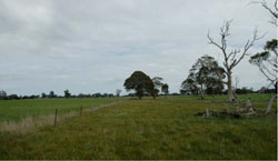 Along a fence line on a gently undulating plain |
Component | 1 | 2 | 3 | 4 | 5 |
Proportion of soil-landform unit | 5% | 5% | 5% | 70% | 15% |
| CLIMATE Rainfall (mm) | Annual: 500 | ||||
| Temperature (oC) | Minimum 8, Maximum 20 | ||||
| Precipitation less than potential evapotranspiration | October–April | ||||
| GEOLOGY Age and lithology | Neogene marine sand and silt (Parilla Sand); Neogene marine sand, sandstone, silt and laterite (Dorodong Sand); Quaternary aeolian dune sand, paludal silt and clay | ||||
| Geomorphology | |||||
| LANDUSE | Uncleared areas: Water supply; nature conservation; gravel extraction Cleared areas: Dryland cropping; sheep and beef cattle grazing; water supply | ||||
| TOPOGRAPHY Landscape | Broadly dissected valleys | ||||
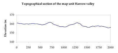
| Elevation range (m) | 148–180 | ||||
| Local relief (m) | 15–45 | ||||
| Drainage pattern | Dendritic | ||||
| Drainage density (km/km2) | 0.3 | ||||
| Landform | Escarpments | Plains | |||
| Landform element | Upper slope | Lower slope | Valley flat | Undulating plain | Drainage depression |
| Slope and range (%) | 7 (3-20) | 5 (2-12) | 1 (0-3) | 2 (1-4) | 1 (0-2) |
| Slope shape | Convex | Convex | Straight | Straight | Concave |
| NATIVE VEGETATION Ecological Vegetation Class | Shallow Sands Woodland (57.1%), Heathy Woodland (14.3%), Other (21.4%) | ||||
| SOIL Parent material | Marine sand and silt | Marine sand and silt | Marine sand and silt | Marine sand and silt, aeolian dune sand | Marine sand and silt |
| Description (Corangamite Soil Group) | Brown and yellow texture contrast soils (19) | Brown and yellow texture contrast soils (19) | Brown and yellow texture contrast soils (sandy surfaces) (17) | Sodic brown and yellow texture contrast soils (sandy surfaces) (18) | Brown and yellow texture contrast soils (19) |
| Soil type sites | |||||
| Surface texture | Sandy loam | Sandy loam | Sandy loam | Lomy sand | Sandy loam |
| Permeability | Slow | Slow | Moderate | Moderate | Slow |
| Depth (m) | 0.8-2.0 | 0.8-2.0 | > 2 | 1.4 | 0.8-2.0 |
| LAND CHARACTERISTICS, POTENTIAL AND LIMITATIONS Critical land features, processes, forms | Light sandy surfaces are generally well drained with heavy subsoils/hardpans restricting further water infiltration. Surfaces may be susceptible to sheet and wind erosion where exposed. Compaction may occur where critical moisture contents exceed soil strength. | Light sandy surfaces are generally well drained with heavy subsoils/hardpans restricting further water infiltration. Surfaces may be susceptible to sheet and wind erosion where exposed. Compaction may occur where critical moisture contents exceed soil strength. | Flat areas subject to inundation and waterlogging, susceptible to gully erosion where sodic subsoil is exposed. Light sandy surface soils generally well drained to subsoil or hardpan. Weakly coherent surfaces with little organic matter are susceptible to sheet and wind erosion where exposed. Soil may be susceptible to compaction. Acidic, low inherent fertility surface soils. | Plains experience periodic inundation and waterlogging in low lying areas. Light sandy surface soils generally well drained to subsoil or hardpan. Acidic with low inherent fertility. Weakly coherent surfaces (above subsoil or hardpan) with little organic matter are susceptible to sheet and wind erosion where exposed. Fragile surface horizons may be susceptible to compaction. | Depressions susceptible to seasonal inundation and waterlogging. Light sandy surfaces are generally well drained with heavy subsoils/hardpans restricting further water infiltration. Surfaces may be susceptible to sheet and wind erosion where exposed. Compaction may occur where critical moisture contents exceed soil strength. |
© State of Victoria (Agriculture Victoria) 1996 - .

This work, Victorian Resources Online, is licensed under a Creative Commons Attribution 4.0 licence. You are free to re-use the work under that licence, on the condition that you credit the State of Victoria (Agriculture Victoria) as author, indicate if changes were made and comply with the other licence terms.
The licence does not apply to ‘branding’ or some ‘images or photographs’ that may be owned by third parties. We ask you to seek prior approval to use images using the VRO feedback form. Access to higher quality images can also be provided on request.
This page was last updated on .