
Soil/Landform Unit - Dooen eroded plain
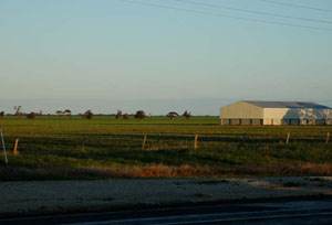 Cleared low rises at Dooen used for pastoral runs and cropping |
0.25% of CMA region Eroded plains in the central east of the region are some of the most productive cropping landscapes of the region. The plains at Dooen are part of the clay plains with subdued ridges of the North Western Dunefields and Plains (5.4). This unit has a sequence of very gentle rise crests and slopes with lower plains and drainage lines. Soils are typically either cracking clay soils (Vertosols) and/or sodic red texture contrast soils (Sodosols). While land use is dominated by dryland cereal cropping, surface condition can be quite variable depending upon soil type. The red sodic texture contrast soils have hardsetting surfaces that are prone to compaction while the cracking clay soils tend to have self-mulching surfaces that have a higher resilience to cultivation. Vegetation communities include Floodplain Riparian Woodland, Low Rises Woodland, Riverine Chenopod Woodland, Plains Grassland, Red Gum Wetland, Plains Woodland and Plains Savannah. |  |
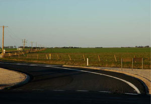 Looking towards crest of low gentle rise across plain | 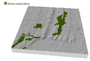 |
 | 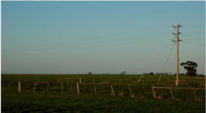 Cleared plain with little remnant vegetation in distance |
Component | 1 | 2 | 3 | 4 |
Proportion of soil-landform unit | 5% | 10% | 10% | 75% |
| CLIMATE Rainfall (mm) | Annual: 440 | |||
| Temperature (oC) | Minimum 8, Maximum 21 | |||
| Precipitation less than potential evapotranspiration | September–April | |||
| GEOLOGY Age and lithology | ||||
| Geomorphology | ||||
| LANDUSE | Uncleared areas: Nature conservation Cleared areas: Dryland cropping; sheep grazing | |||
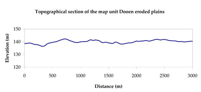
| TOPOGRAPHY Landscape | Eroded plain | |||
| Elevation range (m) | 124–146 | |||
| Local relief (m) | 5 | |||
| Drainage pattern | Dendritic | |||
| Drainage density (km/km2) | 0.6 | |||
| Landform | Low rises | Plains | ||
| Landform element | Rise crest | Low rise slope | Drainage line | Plain |
| Slope and range (%) | 3 (2-6) | 2 (1-5) | 1 (0-3) | 3 (0-5) |
| Slope shape | Convex | Linear | Concave | Straight |
| NATIVE VEGETATION Ecological Vegetation Class | Plains Woodland (47.3%), Plains Savannah (41.0%), Other (8.4%) | |||
| SOIL Parent material | Marine sand and silt | Marine sand and silt | Alluvial gravel, sand and silt | Alluvial silt and clay |
| Description (Corangamite Soil Group) | Sodic red texture contrast soils (39) | Cracking clay soils (34) | Cracking clay soils (34) | |
| Soil type sites | ||||
| Surface texture | Sandy loam to clay loam | Light clay | Medium clay | Medium clay |
| Permeability | Moderate | Moderate | Slow | Moderate to slow |
| Depth (m) | > 1.2 | > 3 | > 3 | > 3 |
| LAND CHARACTERISTICS, POTENTIAL AND LIMITATIONS Critical land features, processes, forms | Hardsetting upper soil susceptible to sheet and rill erosion where topsoils are weakly structure. Compaction of upper soil variable depending on soil depth and moisture content. Upper soil is slightly susceptible to acidification. | Surface condition is variable from self-mulching (cracking clays) to hardsetting (texture contrast soils). High clay content soils have variable site drainage which can be due to micro relief (gilgai). Surface soils are friable and only slightly susceptible to wind erosion due to self-mulching nature. | High clay content results in restricted soil drainage. Surface soils are generally friable and only slightly susceptible to wind erosion due to self-mulching and massive nature. Soils may be susceptible at critical moisture contents and have variable resilience to compaction. | High clay content soils with variable site drainage which can be variable due to micro relief (gilgai). Surface soils are friable and only slightly susceptible to wind erosion due to self-mulching nature. Soils may be susceptible at critical moisture contents and have variable resilience to compaction. |
© State of Victoria (Agriculture Victoria) 1996 - .

This work, Victorian Resources Online, is licensed under a Creative Commons Attribution 4.0 licence. You are free to re-use the work under that licence, on the condition that you credit the State of Victoria (Agriculture Victoria) as author, indicate if changes were made and comply with the other licence terms.
The licence does not apply to ‘branding’ or some ‘images or photographs’ that may be owned by third parties. We ask you to seek prior approval to use images using the VRO feedback form. Access to higher quality images can also be provided on request.
This page was last updated on .