
Soil/Landform Unit - Brimpaen undulating plains
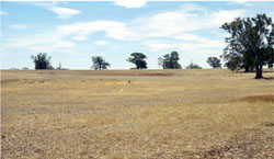
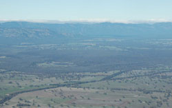 Undulating plains surrounding MacKenzie River near Brimpaen |
0.24% of CMA region The plain between the western Black Range and the Grampians is flat to undulating with woodlands and forms part of the low relief, low drainage density plateaux of the eastern Dundas Tablelands (2.3.2). This soil-landform unit is linked to the Dundas Tablelands through its similar geomorphology and geology including Neogene marine deposits and extensive regolith development. Little stream dissection occurs with rises of Parilla Sand located within broad undulating plains. Soils are cracking clay soils on the plains with sodic and non-sodic, brown and red texture contrast soils located on these infrequent rises. Plains are susceptible to inundation and waterlogging with heavy subsoils/hardpans that restrict deep water infiltration. Land use has traditionally been dominated by grazing (sheep and cattle), however the introduction of raised beds etc. has seen large volumes of surface water removed from once previously seasonally waterlogged soils. Native vegetation communities are dominated by woodland vegetation including Heathy Woodland, Plains Grassy Woodland, Hills Herb-rich Woodland, Dry Creekline Woodland, Lateritic Woodland and Plains Woodland. | 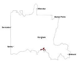 |
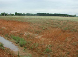 Cutting through the Parilla Sand east of Brimpaen | 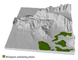 |
|
|
Component | 1 | 2 | 3 |
Proportion of soil-landform unit | 60% | 10% | 30% |
| CLIMATE Rainfall (mm) | Annual: 730 | ||
| Temperature (oC) | Minimum 8, Maximum 20 | ||
| Precipitation less than potential evapotranspiration | October–March | ||
| GEOLOGY Age and lithology | Quaternary alluvium, gravel, sand and silt; Neogene marine sand, sandstone, silt, laterite (Dorodong Sand); | ||
| Geomorphology | |||
| LANDUSE | Uncleared areas: water supply; nature conservation; gravel and mineral sand extraction Cleared areas: dryland cropping; sheep and beef cattle grazing; water supply | ||
| TOPOGRAPHY Landscape | Undulating plain | ||
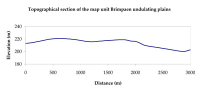
| Elevation range (m) | 175–350 | ||
| Local relief (m) | 2 (up to 10 for local rises) | ||
| Drainage pattern | Dendritic | ||
| Drainage density (km/km2) | 0.6 | ||
| Landform | Plains | ||
| Landform element | Gentle undulating plain | Drainage line | Rise |
| Slope and range (%) | 2 (1-3) | 5 (2-9) | 8 (3-13) |
| Slope shape | Straight | Concave | Convex |
| NATIVE VEGETATION Ecological Vegetation Class | Heathy Woodland (26.1%), Plains Grassy Woodland (21.0%), Lateritic Woodland (11.8%), Dry Creekline Woodland (8.0%), Creekline Sedgy Woodland (7.5%), Other (22.4%) | ||
| SOIL Parent material | Alluvial sand and silt, minor gravel | Alluvial gravel, sand and silt | Marine sand, sandstone and silt |
| Description (Corangamite Soil Group) | Cracking clay soils (20) | Cracking clay soils (20) | Sodic and non-sodic, brown and red texture contrast soils (6) |
| Soil type sites | |||
| Surface texture | Clay loam to light clay | Light medium clay | Sandy loam (silty) |
| Permeability | Slow | Slow | Moderate |
| Depth (m) | > 2 | > 2 | 1.5 |
| LAND CHARACTERISTICS, POTENTIAL AND LIMITATIONS Critical land features, processes, forms | Plains are susceptible to inundation and waterlogging with heavy subsoils/hardpans that restrict deep water infiltration. Surfaces may be susceptible to sheet and wind erosion where exposed. Compaction may occur where critical moisture contents exceed soil strength. | Depressions are susceptible to inundation and waterlogging. Surfaces may be susceptible to sheet and wind erosion where exposed. Compaction may occur where critical moisture contents exceed soil strength. | Hardsetting and soft surfaces susceptible to sheet and rill erosion even on gentle slope due to impeding layer (clay or ferricrete). Subsurface soil and upper subsoil susceptible to compaction, and also gully erosion where sodic subsoils are exposed. Topsoil may be susceptible to acidification. |
© State of Victoria (Agriculture Victoria) 1996 - .

This work, Victorian Resources Online, is licensed under a Creative Commons Attribution 4.0 licence. You are free to re-use the work under that licence, on the condition that you credit the State of Victoria (Agriculture Victoria) as author, indicate if changes were made and comply with the other licence terms.
The licence does not apply to ‘branding’ or some ‘images or photographs’ that may be owned by third parties. We ask you to seek prior approval to use images using the VRO feedback form. Access to higher quality images can also be provided on request.
This page was last updated on .