
Soil/Landform Unit - Balmoral undulating plains
 Looking south over the Douglas Depression towards the plains leading to the Glenelg River |
0.14% of CMA region Undulating plains dominated by Neogene marine deposits characterise this soil-landform unit. Occurring on the southern boundary of the Wimmera CMA region, the plains line the northern boundary of the Glenelg River to the south with its prominent valley slopes and floor. This unit is part of the low relief, low drainage density of the eastern Dundas Tablelands. Land use is dominantly grazing (cattle and sheep) and dryland cropping with waterlogging and seasonal inundation an issue in years of near or above mean annual rainfall (610 mm). Soils are typically brown and yellow texture contrast soils with sandy surfaces and sodic subsoils on plains and slopes, with drainage depressions consisting largely of cracking clays. Heathy Woodland vegetation is the most common remnant vegetation type with a number of other vegetation types such as Plains Grassy Woodland, Alluvial Terraces Herb-rich Woodland, Dry Creekline Woodland, Heathy Herb-rich Woodland, Plains Woodland and Shallow Sands Woodland also present. | 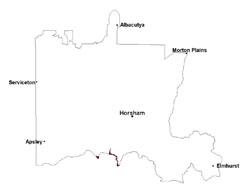 |
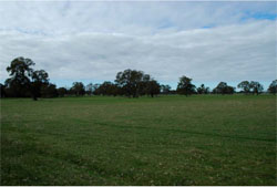 Gentle undualting plains along roadside near Telangatuk, cleared for pastoral use | 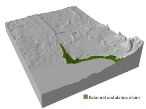 |
| 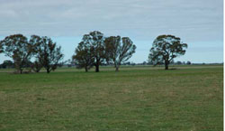 Looking south across gentle undulating plains |
Component | 1 | 2 | 3 | 4 | 5 |
Proportion of soil-landform unit | 15% | 30% | 25% | 25% | 5% |
| CLIMATE Rainfall (mm) | Annual: 610 | ||||
| Temperature (oC) | Minimum 8, Maximum 20 | ||||
| Precipitation less than potential evapotranspiration | October–April | ||||
| GEOLOGY Age and lithology | Quaternary fluvial gravel, sand and silt; Silurian fluvial marine sandstone, siltstone and minor conglomerate (Grampians Group); Neogene deflational laterite; Neogene marine sand, sandstone, silt and laterites (Dorodong Sand) | ||||
| Geomorphology | |||||
| LANDUSE | Uncleared areas: softwood forestry; water supply; nature conservation; gravel extraction Cleared areas: sheep and beef cattle grazing; dryland cropping | ||||
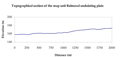
| TOPOGRAPHY Landscape | Undulating plains with a deeply dissected valley | ||||
| Elevation range (m) | 157–252 | ||||
| Local relief (m) | 10 | ||||
| Drainage pattern | Dendritic | ||||
| Drainage density (km/km2) | 0.6 | ||||
| Landform | Valley slopes | Gently undulating plains and valley floors | |||
| Landform element | Crest and upper slope | Mid to lower slope | Gently undulating plain | Flat | Drainage line |
| Slope and range (%) | 5 (1-25) | 5 (2-15) | 2 (0-5) | 0 (0-1) | 1 (0-3) |
| Slope shape | Convex | Convex | Straight | Straight | Concave |
| NATIVE VEGETATION Ecological Vegetation Class | Heathy Woodland (31.3%), Plains Grassy Woodland (27.5%), Heathy Woodland/Plains Grassy Woodland Complex (12.6%), Other (13.7%) | ||||
| SOIL Parent material | Fluvial sandstone, siltstone and minor conglomerate | Fluvial gravel, sand and silt | Lateritic sand, silt and clay | Lateritic sand, silt and clay | Lateritic sand, silt and clay |
| Description (Corangamite Soil Group) | Sodic brown and yellow texture contrast soils (sandy surfaces) (18) | Sodic brown and yellow texture contrast soils (sandy surfaces) (18) | Sodic brown and yellow texture contrast soils (sandy surfaces) (18) | Cracking clay soils (20) | |
| Soil type sites | |||||
| Surface texture | Loamy sand | Loamy sand | Loamy sand | Loamy sand or Light medium clay | Light medium clay |
| Permeability | Moderate | Moderate | Moderate | Moderate to slow | Slow |
| Depth (m) | 1.4 | 1.4 | 1.4 | > 2 | >2 |
| LAND CHARACTERISTICS, POTENTIAL AND LIMITATIONS Critical land features, processes, forms | Flats are subject to inundation and waterlogging and susceptible to gully erosion where subsoil is exposed. Light sandy surface soils generally well drained to subsoil or hardpan. Acidic with low inherent fertility. Weakly coherent surfaces (above subsoil or hardpan) with little organic matter are susceptible to sheet and wind erosion where exposed. Fragile surface horizons may be susceptible to compaction. | Flats are subject to inundation and waterlogging and susceptible to gully erosion where subsoil is exposed. Light sandy surface soils generally well drained to subsoil or hardpan. Acidic with low inherent fertility. Weakly coherent surfaces (above subsoil or hardpan) with little organic matter are susceptible to sheet and wind erosion where exposed. Fragile surface horizons may be susceptible to compaction. | Flats are subject to inundation and waterlogging and susceptible to gully erosion where subsoil is exposed. Light sandy surface soils generally well drained to subsoil or hardpan. Acidic with low inherent fertility. Weakly coherent surfaces (above subsoil or hardpan) with little organic matter are susceptible to sheet and wind erosion where exposed. Fragile surface horizons may be susceptible to compaction. | Flats are subject to inundation and waterlogging and susceptible to gully erosion where subsoil is exposed. Weakly coherent surfaces (above subsoil or hardpan) with little organic matter are susceptible to sheet and wind erosion where exposed. Fragile surface horizons may be susceptible to compaction. | Flats are susceptible to inundation and waterlogging with light sandy surfaces that are generally well drained, overlying heavy subsoils/hardpans that restrict further water infiltration. Surfaces may be susceptible to sheet and wind erosion where exposed. Compaction may occur where critical moisture contents exceed soil strength. |
© State of Victoria (Agriculture Victoria) 1996 - .

This work, Victorian Resources Online, is licensed under a Creative Commons Attribution 4.0 licence. You are free to re-use the work under that licence, on the condition that you credit the State of Victoria (Agriculture Victoria) as author, indicate if changes were made and comply with the other licence terms.
The licence does not apply to ‘branding’ or some ‘images or photographs’ that may be owned by third parties. We ask you to seek prior approval to use images using the VRO feedback form. Access to higher quality images can also be provided on request.
This page was last updated on .